Iowa geodata
Iowa (Louisiana) is a populated place; located in United States in America/Chicago (GMT-5) time zone. With population of 3,219 people, there are 9274 cities with bigger population in this country. Compared to other cities in United States, 92.7% of cities are located further ↑North; 66.3% of cities are located further →East and 91% of cities have higher elevation than Iowa. Note1


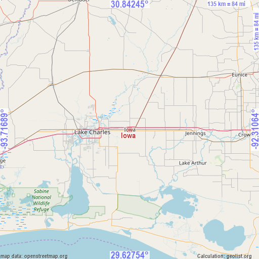
Iowa GPS coordinates[2]
30° 14' 12.732" North, 93° 0' 49.536" West
| Map corner | latitude | longitude |
|---|---|---|
| Upper-left | 30.84245°, | -93.71689° |
| Center: | 30.23687°, | -93.01376° |
| Lower-right: | 29.62754°, | -92.31064° |
| Map W x H: | 135.1×135.1 km | = 83.9×83.9mi |
| max Lat: | 71.29058° ⇑92.7% North |
| Iowa: | 30.23687° |
| min Lat: | ⇓7.3% South 19.06759° |
| min Long | Iowa | max Long |
| -171.73463° | -93.01376° | -66.98998° |
| W 33.7%⇐ | ⇒66.3% E |
Elevation
Elevation of Iowa is 14 m = 46 ft, and this is 280.8 m = 921 ft below average elevation for this country.
| Max E: |
3189 m = 10463 ft | 91% |
| Avg. | 294.8 m = 967 ft | |
| Iowa | 14 m = 46 ft | |
Min E: |
-60 m = -197 ft | 9% |
See also: United States elevation on elevation.city.
Geographical zone
Iowa is located in North temperate zone (between Tropic of Cancer and the Arctic Circle). Distance of this Northern Tropic circle is 756.1 km =469.8 mi to South.| Distance of | km | miles | from Iowa |
|---|---|---|---|
| North Pole | 6645 | 4129 | to North |
| Arctic Circle | 4039.1 | 2509.8 | to North |
| Tropic Cancer | 756.1 | 469.8 | to South |
| Equator | 3362 | 2089 | to South |


Nearby cities:
15 places around Iowa: (largest is in red/bold)
• Carlyss
35.6 km =22.1 mi,  257°
257°
• Elton
40.9 km =25.4 mi,  48°
48°
• Gillis
23.6 km =14.7 mi,  310°
310°
• Hackberry
41.4 km =25.7 mi,  229°
229°
• Hayes
16.8 km =10.4 mi,  147°
147°
• Jennings
34.3 km =21.3 mi,  92°
92°
• Kinder
31.8 km =19.8 mi,  29°
29°
• Lake Arthur
37.2 km =23.1 mi,  117°
117°
• Lake Charles
18.5 km =11.5 mi, 261°
• Moss Bluff
18.5 km =11.5 mi,  293°
293°
• Prien
25.7 km =16 mi, 256°
• Roanoke
25.6 km =15.9 mi, 90°
• Sulphur
34.9 km =21.7 mi,  269°
269°
• Welsh
18.4 km =11.4 mi, 90°
• Westlake
22.8 km =14.2 mi, 271°
Sources, notices
• [Note1] Compared only with cities in United States existing in our database
• [Src1] Map data: © OpenStreetMap contributors (CC-BY-SA)
• [Src2] Other city data from geonames.org with taken over terms of usage.
• [Src3] Geographical zone / Annual Mean Temperature by Robert A. Rohde @ Wikipedia
