Lake Charles geodata
Lake Charles (Louisiana) is a seat of a second-order administrative division; located in United States in America/Chicago (GMT-5) time zone. With population of 76,070 people, there are 529 cities with bigger population in this country. Compared to other cities in United States, 92.7% of cities are located further ↑North; 66.7% of cities are located further →East and 97.4% of cities have higher elevation than Lake Charles. Note1


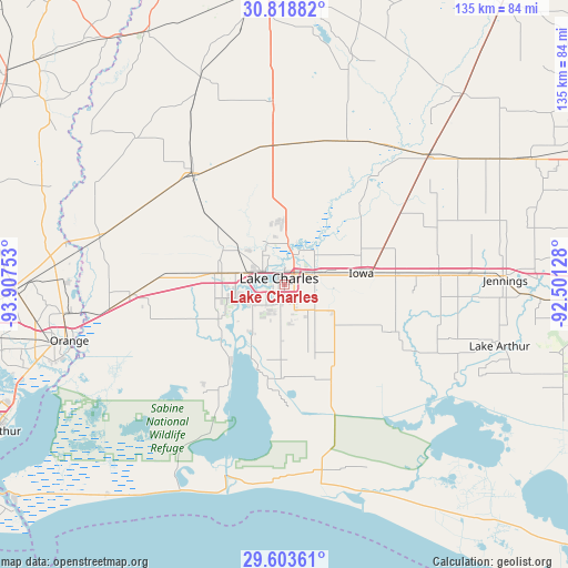
Lake Charles GPS coordinates[2]
30° 12' 47.124" North, 93° 12' 15.84" West
| Map corner | latitude | longitude |
|---|---|---|
| Upper-left | 30.81882°, | -93.90753° |
| Center: | 30.21309°, | -93.2044° |
| Lower-right: | 29.60361°, | -92.50128° |
| Map W x H: | 135.1×135.1 km | = 83.9×83.9mi |
| max Lat: | 71.29058° ⇑92.7% North |
| Lake Charles: | 30.21309° |
| min Lat: | ⇓7.3% South 19.06759° |
| min Long | Lake Charles | max Long |
| -171.73463° | -93.2044° | -66.98998° |
| W 33.3%⇐ | ⇒66.7% E |
Elevation
Elevation of Lake Charles is 6 m = 20 ft, and this is 288.8 m = 948 ft below average elevation for this country.
| Max E: |
3189 m = 10463 ft | 97.4% |
| Avg. | 294.8 m = 967 ft | |
| Lake Charles | 6 m = 20 ft | |
Min E: |
-60 m = -197 ft | 2.6% |
See also: Lake Charles elevation on elevation.city.
Geographical zone
Lake Charles is located in North temperate zone (between Tropic of Cancer and the Arctic Circle). Distance of this Northern Tropic circle is 753.5 km =468.2 mi to South.| Distance of | km | miles | from Lake Charles |
|---|---|---|---|
| North Pole | 6647.7 | 4130.7 | to North |
| Arctic Circle | 4041.8 | 2511.5 | to North |
| Tropic Cancer | 753.5 | 468.2 | to South |
| Equator | 3359.4 | 2087.4 | to South |


Nearby cities:
15 places around Lake Charles: (largest is in red/bold)
• Carlyss
17.2 km =10.7 mi,  253°
253°
• DeQuincy
34.3 km =21.3 mi,  320°
320°
• Gillis
17.9 km =11.1 mi,  1°
1°
• Hackberry
27.5 km =17.1 mi,  208°
208°
• Hayes
29.7 km =18.5 mi,  112°
112°
• Iowa
18.5 km =11.5 mi,  81°
81°
• Longville
43.7 km =27.2 mi,  356°
356°
• Moss Bluff
10.1 km =6.3 mi,  7°
7°
• Prien
7.5 km =4.7 mi,  242°
242°
• Roanoke
44 km =27.3 mi,  86°
86°
• Starks
45.4 km =28.2 mi,  284°
284°
• Sulphur
16.8 km =10.4 mi, 278°
• Vinton
36.3 km =22.6 mi,  266°
266°
• Welsh
36.8 km =22.9 mi, 86°
• Westlake
5.5 km =3.4 mi,  305°
305°
Sources, notices
• [Note1] Compared only with cities in United States existing in our database
• [Src1] Map data: © OpenStreetMap contributors (CC-BY-SA)
• [Src2] Other city data from geonames.org with taken over terms of usage.
• [Src3] Geographical zone / Annual Mean Temperature by Robert A. Rohde @ Wikipedia
