Kinder geodata
Kinder (Louisiana) is a populated place; located in United States in America/Chicago (GMT-5) time zone. With population of 2,442 people, there are 10759 cities with bigger population in this country. Compared to other cities in United States, 91.9% of cities are located further ↑North; 66% of cities are located further →East and 88.6% of cities have higher elevation than Kinder. Note1


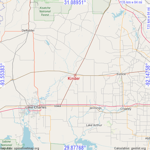
Kinder GPS coordinates[2]
30° 29' 7.728" North, 92° 51' 2.52" West
| Map corner | latitude | longitude |
|---|---|---|
| Upper-left | 31.08951°, | -93.55383° |
| Center: | 30.48548°, | -92.8507° |
| Lower-right: | 29.87768°, | -92.14758° |
| Map W x H: | 134.7×134.7 km | = 83.7×83.7mi |
| max Lat: | 71.29058° ⇑91.9% North |
| Kinder: | 30.48548° |
| min Lat: | ⇓8.1% South 19.06759° |
| min Long | Kinder | max Long |
| -171.73463° | -92.8507° | -66.98998° |
| W 34%⇐ | ⇒66% E |
Elevation
Elevation of Kinder is 19 m = 62 ft, and this is 275.8 m = 905 ft below average elevation for this country.
| Max E: |
3189 m = 10463 ft | 88.6% |
| Avg. | 294.8 m = 967 ft | |
| Kinder | 19 m = 62 ft | |
Min E: |
-60 m = -197 ft | 11.4% |
See also: United States elevation on elevation.city.
Geographical zone
Kinder is located in North temperate zone (between Tropic of Cancer and the Arctic Circle). Distance of this Northern Tropic circle is 783.7 km =487 mi to South.| Distance of | km | miles | from Kinder |
|---|---|---|---|
| North Pole | 6617.4 | 4111.9 | to North |
| Arctic Circle | 4011.5 | 2492.6 | to North |
| Tropic Cancer | 783.7 | 487 | to South |
| Equator | 3389.7 | 2106.3 | to South |


Nearby cities:
15 places around Kinder: (largest is in red/bold)
• Basile
24.4 km =15.2 mi,  90°
90°
• Elton
14.9 km =9.3 mi, 91°
• Eunice
41.5 km =25.8 mi, 88°
• Gillis
35.8 km =22.2 mi,  249°
249°
• Hayes
42.4 km =26.3 mi,  189°
189°
• Iota
38.1 km =23.7 mi,  116°
116°
• Iowa
31.8 km =19.8 mi,  209°
209°
• Jennings
34.6 km =21.5 mi,  147°
147°
• Longville
38.8 km =24.1 mi,  290°
290°
• Mermentau
41.7 km =25.9 mi,  141°
141°
• Moss Bluff
38.4 km =23.9 mi,  238°
238°
• Oakdale
41 km =25.5 mi,  26°
26°
• Oberlin
17.2 km =10.7 mi, 29°
• Roanoke
29.4 km =18.3 mi,  160°
160°
• Welsh
27.9 km =17.3 mi,  174°
174°
Sources, notices
• [Note1] Compared only with cities in United States existing in our database
• [Src1] Map data: © OpenStreetMap contributors (CC-BY-SA)
• [Src2] Other city data from geonames.org with taken over terms of usage.
• [Src3] Geographical zone / Annual Mean Temperature by Robert A. Rohde @ Wikipedia
