Natchez geodata
Natchez (Louisiana) is a populated place; located in United States in America/Chicago (GMT-5) time zone. With population of 588 people, there are 19837 cities with bigger population in this country. Compared to other cities in United States, 89.3% of cities are located further ↑North; 66.3% of cities are located further →East and 82.6% of cities have higher elevation than Natchez. Note1


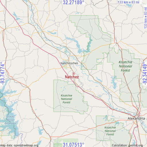
Natchez GPS coordinates[2]
31° 40' 31.584" North, 93° 2' 40.596" West
| Map corner | latitude | longitude |
|---|---|---|
| Upper-left | 32.27189°, | -93.74774° |
| Center: | 31.67544°, | -93.04461° |
| Lower-right: | 31.07513°, | -92.34149° |
| Map W x H: | 133.1×133.1 km | = 82.7×82.7mi |
| max Lat: | 71.29058° ⇑89.3% North |
| Natchez: | 31.67544° |
| min Lat: | ⇓10.7% South 19.06759° |
| min Long | Natchez | max Long |
| -171.73463° | -93.04461° | -66.98998° |
| W 33.7%⇐ | ⇒66.3% E |
Elevation
Elevation of Natchez is 36 m = 118 ft, and this is 258.8 m = 849 ft below average elevation for this country.
| Max E: |
3189 m = 10463 ft | 82.6% |
| Avg. | 294.8 m = 967 ft | |
| Natchez | 36 m = 118 ft | |
Min E: |
-60 m = -197 ft | 17.4% |
See also: United States elevation on elevation.city.
Geographical zone
Natchez is located in North temperate zone (between Tropic of Cancer and the Arctic Circle). Distance of this Northern Tropic circle is 916.1 km =569.2 mi to South.| Distance of | km | miles | from Natchez |
|---|---|---|---|
| North Pole | 6485.1 | 4029.7 | to North |
| Arctic Circle | 3879.2 | 2410.4 | to North |
| Tropic Cancer | 916.1 | 569.2 | to South |
| Equator | 3522 | 2188.5 | to South |


Nearby cities:
15 places around Natchez: (largest is in red/bold)
• Boyce
47.6 km =29.6 mi,  131°
131°
• Campti
25.2 km =15.7 mi,  343°
343°
• Colfax
36.4 km =22.6 mi,  118°
118°
• Coushatta
47.1 km =29.3 mi,  323°
323°
• Florien
46.8 km =29.1 mi,  236°
236°
• Fort Jesup
34.6 km =21.5 mi,  258°
258°
• Many
43.3 km =26.9 mi,  254°
254°
• Martin
48.5 km =30.1 mi, 340°
• Montgomery
14.6 km =9.1 mi,  93°
93°
• Natchitoches
10.3 km =6.4 mi, 337°
• Pleasant Hill
47.2 km =29.3 mi,  289°
289°
• Provencal
15.1 km =9.4 mi, 260°
• Simpson
47.9 km =29.8 mi,  176°
176°
• Vienna Bend
6.3 km =3.9 mi,  3°
3°
• Winnfield
47.2 km =29.3 mi,  53°
53°
Sources, notices
• [Note1] Compared only with cities in United States existing in our database
• [Src1] Map data: © OpenStreetMap contributors (CC-BY-SA)
• [Src2] Other city data from geonames.org with taken over terms of usage.
• [Src3] Geographical zone / Annual Mean Temperature by Robert A. Rohde @ Wikipedia
