Winnfield geodata
Winnfield (Louisiana) is a seat of a second-order administrative division; located in United States in America/Chicago (GMT-5) time zone. With population of 4,565 people, there are 7580 cities with bigger population in this country. Compared to other cities in United States, 88.8% of cities are located further ↑North; 65.5% of cities are located further →East and 80.1% of cities have higher elevation than Winnfield. Note1


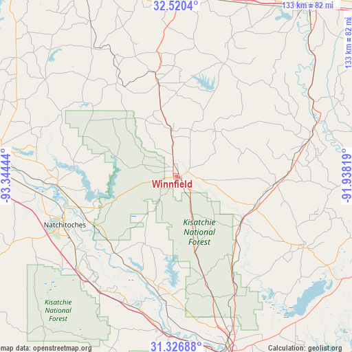
Winnfield GPS coordinates[2]
31° 55' 32.088" North, 92° 38' 28.716" West
| Map corner | latitude | longitude |
|---|---|---|
| Upper-left | 32.5204°, | -93.34444° |
| Center: | 31.92558°, | -92.64131° |
| Lower-right: | 31.32688°, | -91.93819° |
| Map W x H: | 132.7×132.7 km | = 82.5×82.5mi |
| max Lat: | 71.29058° ⇑88.8% North |
| Winnfield: | 31.92558° |
| min Lat: | ⇓11.2% South 19.06759° |
| min Long | Winnfield | max Long |
| -171.73463° | -92.64131° | -66.98998° |
| W 34.5%⇐ | ⇒65.5% E |
Elevation
Elevation of Winnfield is 46 m = 151 ft, and this is 248.8 m = 816 ft below average elevation for this country.
| Max E: |
3189 m = 10463 ft | 80.1% |
| Avg. | 294.8 m = 967 ft | |
| Winnfield | 46 m = 151 ft | |
Min E: |
-60 m = -197 ft | 19.9% |
See also: United States elevation on elevation.city.
Geographical zone
Winnfield is located in North temperate zone (between Tropic of Cancer and the Arctic Circle). Distance of this Northern Tropic circle is 943.9 km =586.5 mi to South.| Distance of | km | miles | from Winnfield |
|---|---|---|---|
| North Pole | 6457.3 | 4012.4 | to North |
| Arctic Circle | 3851.4 | 2393.1 | to North |
| Tropic Cancer | 943.9 | 586.5 | to South |
| Equator | 3549.8 | 2205.7 | to South |


Nearby cities:
15 places around Winnfield: (largest is in red/bold)
• Banks Springs
54.6 km =33.9 mi,  71°
71°
• Campti
45.2 km =28.1 mi,  265°
265°
• Chatham
46 km =28.6 mi,  23°
23°
• Clarks
48.7 km =30.3 mi,  76°
76°
• Colfax
45.6 km =28.3 mi,  187°
187°
• Grayson
52 km =32.3 mi, 74°
• Jena
55 km =34.2 mi,  119°
119°
• Jonesboro
35.8 km =22.2 mi,  348°
348°
• Midway
53 km =32.9 mi, 119°
• Montgomery
37.1 km =23.1 mi,  219°
219°
• Natchez
47.2 km =29.3 mi,  233°
233°
• Natchitoches
45.9 km =28.5 mi,  246°
246°
• Olla
37.7 km =23.4 mi,  93°
93°
• Urania
33.3 km =20.7 mi,  101°
101°
• Vienna Bend
43.4 km =27 mi,  240°
240°
Sources, notices
• [Note1] Compared only with cities in United States existing in our database
• [Src1] Map data: © OpenStreetMap contributors (CC-BY-SA)
• [Src2] Other city data from geonames.org with taken over terms of usage.
• [Src3] Geographical zone / Annual Mean Temperature by Robert A. Rohde @ Wikipedia
