Simpson geodata
Simpson (Louisiana) is a populated place; located in United States in America/Chicago (GMT-5) time zone. With population of 618 people, there are 19489 cities with bigger population in this country. Compared to other cities in United States, 90.2% of cities are located further ↑North; 66.3% of cities are located further →East and 74.2% of cities have higher elevation than Simpson. Note1


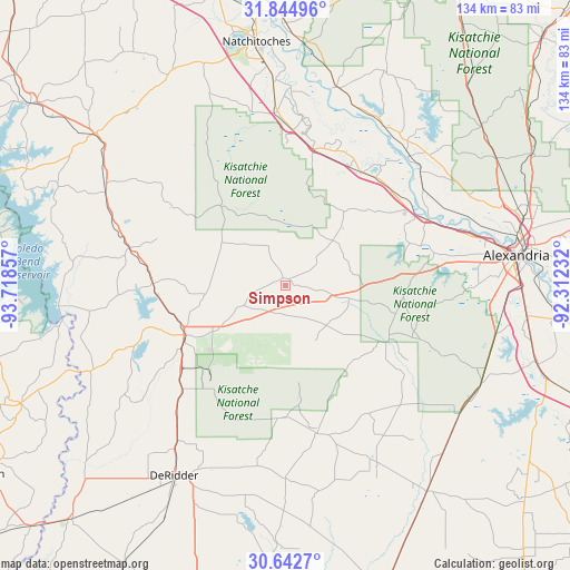
Simpson GPS coordinates[2]
31° 14' 44.664" North, 93° 0' 55.584" West
| Map corner | latitude | longitude |
|---|---|---|
| Upper-left | 31.84496°, | -93.71857° |
| Center: | 31.24574°, | -93.01544° |
| Lower-right: | 30.6427°, | -92.31232° |
| Map W x H: | 133.7×133.7 km | = 83.1×83.1mi |
| max Lat: | 71.29058° ⇑90.2% North |
| Simpson: | 31.24574° |
| min Lat: | ⇓9.8% South 19.06759° |
| min Long | Simpson | max Long |
| -171.73463° | -93.01544° | -66.98998° |
| W 33.7%⇐ | ⇒66.3% E |
Elevation
Elevation of Simpson is 76 m = 249 ft, and this is 218.8 m = 718 ft below average elevation for this country.
| Max E: |
3189 m = 10463 ft | 74.2% |
| Avg. | 294.8 m = 967 ft | |
| Simpson | 76 m = 249 ft | |
Min E: |
-60 m = -197 ft | 25.8% |
See also: United States elevation on elevation.city.
Geographical zone
Simpson is located in North temperate zone (between Tropic of Cancer and the Arctic Circle). Distance of this Northern Tropic circle is 868.3 km =539.5 mi to South.| Distance of | km | miles | from Simpson |
|---|---|---|---|
| North Pole | 6532.9 | 4059.4 | to North |
| Arctic Circle | 3927 | 2440.1 | to North |
| Tropic Cancer | 868.3 | 539.5 | to South |
| Equator | 3474.2 | 2158.8 | to South |


Nearby cities:
15 places around Simpson: (largest is in red/bold)
• Anacoco
31 km =19.3 mi,  271°
271°
• Boyce
36.6 km =22.7 mi,  63°
63°
• Colfax
42.2 km =26.2 mi,  43°
43°
• Elizabeth
47 km =29.2 mi,  153°
153°
• Florien
47.4 km =29.5 mi,  297°
297°
• Fort Polk North
22.2 km =13.8 mi,  224°
224°
• Fort Polk South
28.8 km =17.9 mi, 221°
• Leesville
26 km =16.2 mi,  244°
244°
• Montgomery
48.4 km =30.1 mi,  14°
14°
• Natchez
47.9 km =29.8 mi,  356°
356°
• New Llano
28.4 km =17.6 mi, 239°
• Pitkin
35.2 km =21.9 mi,  167°
167°
• Provencal
48.6 km =30.2 mi,  338°
338°
• Rosepine
44.3 km =27.5 mi, 215°
• Woodworth
50.5 km =31.4 mi,  102°
102°
Sources, notices
• [Note1] Compared only with cities in United States existing in our database
• [Src1] Map data: © OpenStreetMap contributors (CC-BY-SA)
• [Src2] Other city data from geonames.org with taken over terms of usage.
• [Src3] Geographical zone / Annual Mean Temperature by Robert A. Rohde @ Wikipedia
