Bawcomville geodata
Bawcomville (Louisiana) is a populated place; located in United States in America/Chicago (GMT-5) time zone. With population of 3,588 people, there are 8738 cities with bigger population in this country. Compared to other cities in United States, 87.2% of cities are located further ↑North; 64.5% of cities are located further →East and 84.1% of cities have higher elevation than Bawcomville. Note1


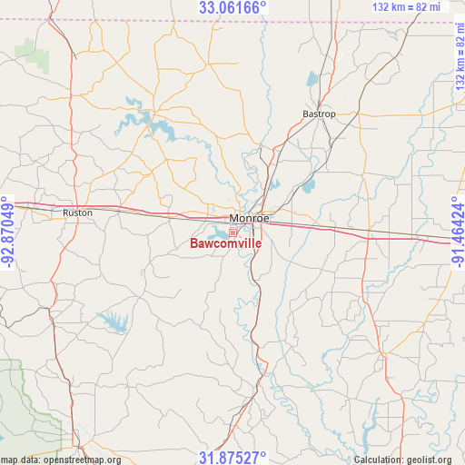
Bawcomville GPS coordinates[2]
32° 28' 13.512" North, 92° 10' 2.496" West
| Map corner | latitude | longitude |
|---|---|---|
| Upper-left | 33.06166°, | -92.87049° |
| Center: | 32.47042°, | -92.16736° |
| Lower-right: | 31.87527°, | -91.46424° |
| Map W x H: | 131.9×131.9 km | = 82×82mi |
| max Lat: | 71.29058° ⇑87.2% North |
| Bawcomville: | 32.47042° |
| min Lat: | ⇓12.8% South 19.06759° |
| min Long | Bawcomville | max Long |
| -171.73463° | -92.16736° | -66.98998° |
| W 35.5%⇐ | ⇒64.5% E |
Elevation
Elevation of Bawcomville is 31 m = 102 ft, and this is 263.8 m = 865 ft below average elevation for this country.
| Max E: |
3189 m = 10463 ft | 84.1% |
| Avg. | 294.8 m = 967 ft | |
| Bawcomville | 31 m = 102 ft | |
Min E: |
-60 m = -197 ft | 15.9% |
See also: United States elevation on elevation.city.
Geographical zone
Bawcomville is located in North temperate zone (between Tropic of Cancer and the Arctic Circle). Distance of this Northern Tropic circle is 1004.5 km =624.2 mi to South.| Distance of | km | miles | from Bawcomville |
|---|---|---|---|
| North Pole | 6396.7 | 3974.7 | to North |
| Arctic Circle | 3790.8 | 2355.5 | to North |
| Tropic Cancer | 1004.5 | 624.2 | to South |
| Equator | 3610.4 | 2243.4 | to South |


Nearby cities:
15 places around Bawcomville: (largest is in red/bold)
• Brownsville
2.2 km =1.4 mi,  33°
33°
• Calhoun
18.5 km =11.5 mi,  284°
284°
• Chatham
32.2 km =20 mi,  235°
235°
• Choudrant
33.2 km =20.6 mi, 281°
• Claiborne
5.6 km =3.5 mi,  335°
335°
• Farmerville
40.4 km =25.1 mi,  326°
326°
• Lakeshore
14.8 km =9.2 mi,  60°
60°
• Mangham
41 km =25.5 mi,  115°
115°
• Monroe
6.2 km =3.9 mi,  46°
46°
• Rayville
38.7 km =24 mi,  88°
88°
• Richwood
8.1 km =5 mi,  107°
107°
• Start
29 km =18 mi, 86°
• Sterlington
26.2 km =16.3 mi,  16°
16°
• Swartz
20.3 km =12.6 mi, 57°
• West Monroe
5.7 km =3.5 mi, 19°
Sources, notices
• [Note1] Compared only with cities in United States existing in our database
• [Src1] Map data: © OpenStreetMap contributors (CC-BY-SA)
• [Src2] Other city data from geonames.org with taken over terms of usage.
• [Src3] Geographical zone / Annual Mean Temperature by Robert A. Rohde @ Wikipedia
