Jena geodata
Jena (Louisiana) is a seat of a second-order administrative division; located in United States in America/Chicago (GMT-5) time zone. With population of 3,417 people, there are 8966 cities with bigger population in this country. Compared to other cities in United States, 89.2% of cities are located further ↑North; 64.4% of cities are located further →East and 78.4% of cities have higher elevation than Jena. Note1


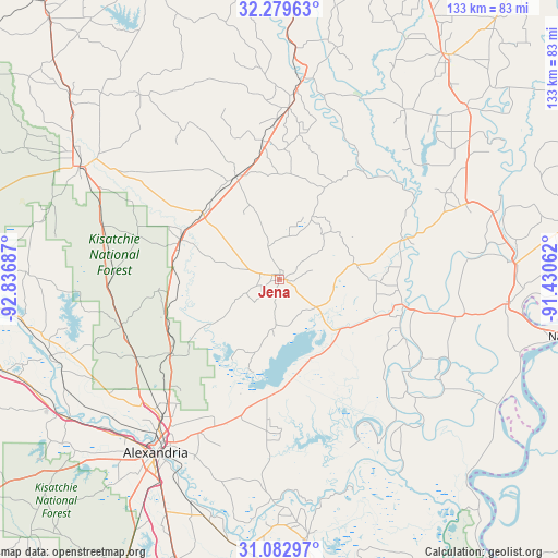
Jena GPS coordinates[2]
31° 40' 59.628" North, 92° 8' 1.464" West
| Map corner | latitude | longitude |
|---|---|---|
| Upper-left | 32.27963°, | -92.83687° |
| Center: | 31.68323°, | -92.13374° |
| Lower-right: | 31.08297°, | -91.43062° |
| Map W x H: | 133.1×133.1 km | = 82.7×82.7mi |
| max Lat: | 71.29058° ⇑89.2% North |
| Jena: | 31.68323° |
| min Lat: | ⇓10.8% South 19.06759° |
| min Long | Jena | max Long |
| -171.73463° | -92.13374° | -66.98998° |
| W 35.6%⇐ | ⇒64.4% E |
Elevation
Elevation of Jena is 54 m = 177 ft, and this is 240.8 m = 790 ft below average elevation for this country.
| Max E: |
3189 m = 10463 ft | 78.4% |
| Avg. | 294.8 m = 967 ft | |
| Jena | 54 m = 177 ft | |
Min E: |
-60 m = -197 ft | 21.6% |
See also: United States elevation on elevation.city.
Geographical zone
Jena is located in North temperate zone (between Tropic of Cancer and the Arctic Circle). Distance of this Northern Tropic circle is 916.9 km =569.7 mi to South.| Distance of | km | miles | from Jena |
|---|---|---|---|
| North Pole | 6484.2 | 4029.1 | to North |
| Arctic Circle | 3878.3 | 2409.9 | to North |
| Tropic Cancer | 916.9 | 569.7 | to South |
| Equator | 3522.8 | 2189 | to South |


Nearby cities:
15 places around Jena: (largest is in red/bold)
• Alexandria
50.8 km =31.6 mi,  215°
215°
• Ball
39.8 km =24.7 mi, 221°
• Banks Springs
44.5 km =27.7 mi,  4°
4°
• Clarks
38.2 km =23.7 mi,  359°
359°
• Columbia
47.2 km =29.3 mi,  6°
6°
• Deville
36.4 km =22.6 mi,  184°
184°
• Grayson
40.8 km =25.4 mi, 3°
• Harrisonburg
31.1 km =19.3 mi,  71°
71°
• Jonesville
30.5 km =19 mi,  101°
101°
• Midway
2 km =1.2 mi,  299°
299°
• Olla
26.5 km =16.5 mi,  337°
337°
• Pineville
49.2 km =30.6 mi, 215°
• Sicily Island
48.7 km =30.3 mi, 68°
• Urania
25.3 km =15.7 mi,  322°
322°
• Wallace Ridge
29.1 km =18.1 mi,  84°
84°
Sources, notices
• [Note1] Compared only with cities in United States existing in our database
• [Src1] Map data: © OpenStreetMap contributors (CC-BY-SA)
• [Src2] Other city data from geonames.org with taken over terms of usage.
• [Src3] Geographical zone / Annual Mean Temperature by Robert A. Rohde @ Wikipedia
