Brandywine geodata
Brandywine (Maryland) is a populated place; located in United States in America/New_York (GMT-4) time zone. With population of 6,719 people, there are 5967 cities with bigger population in this country. Compared to other cities in United States, 57.4% of cities are located further ↑North; 81.2% of cities are located further ←West and 74.9% of cities have higher elevation than Brandywine. Note1


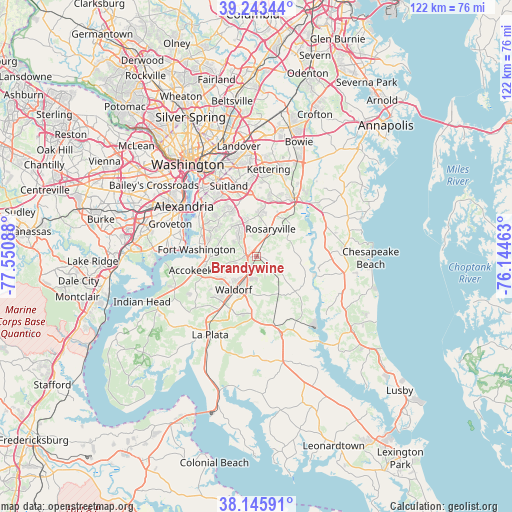
Brandywine GPS coordinates[2]
38° 41' 48.408" North, 76° 50' 51.9" West
| Map corner | latitude | longitude |
|---|---|---|
| Upper-left | 39.24344°, | -77.55088° |
| Center: | 38.69678°, | -76.84775° |
| Lower-right: | 38.14591°, | -76.14463° |
| Map W x H: | 122×122 km | = 75.8×75.8mi |
| max Lat: | 71.29058° ⇑57.4% North |
| Brandywine: | 38.69678° |
| min Lat: | ⇓42.6% South 19.06759° |
| min Long | Brandywine | max Long |
| -171.73463° | -76.84775° | -66.98998° |
| W 81.2%⇐ | ⇒18.8% E |
Elevation
Elevation of Brandywine is 72 m = 236 ft, and this is 222.8 m = 731 ft below average elevation for this country.
| Max E: |
3189 m = 10463 ft | 74.9% |
| Avg. | 294.8 m = 967 ft | |
| Brandywine | 72 m = 236 ft | |
Min E: |
-60 m = -197 ft | 25.1% |
See also: United States elevation on elevation.city.
Geographical zone
Brandywine is located in North temperate zone (between Tropic of Cancer and the Arctic Circle). Distance of this Northern Tropic circle is 1696.8 km =1054.3 mi to South.| Distance of | km | miles | from Brandywine |
|---|---|---|---|
| North Pole | 5704.4 | 3544.5 | to North |
| Arctic Circle | 3098.5 | 1925.3 | to North |
| Tropic Cancer | 1696.8 | 1054.3 | to South |
| Equator | 4302.7 | 2673.6 | to South |


Nearby cities:
15 places around Brandywine: (largest is in red/bold)
• Andrews AFB
12.3 km =7.6 mi,  349°
349°
• Baden
7.4 km =4.6 mi,  124°
124°
• Camp Springs
13 km =8.1 mi,  336°
336°
• Cedarville
5.5 km =3.4 mi,  133°
133°
• Clinton
8.8 km =5.5 mi,  330°
330°
• Croom
9.6 km =6 mi,  49°
49°
• Fort Washington
15.3 km =9.5 mi,  274°
274°
• Friendly
12.9 km =8 mi,  298°
298°
• Marlton
9.9 km =6.2 mi,  30°
30°
• Mellwood
12.8 km =8 mi,  9°
9°
• Queenland
13 km =8.1 mi,  22°
22°
• Rosaryville
7.4 km =4.6 mi, 26°
• Saint Charles
13.1 km =8.1 mi,  217°
217°
• St. Charles
12 km =7.5 mi,  213°
213°
• Waldorf
11.3 km =7 mi, 224°
Sources, notices
• [Note1] Compared only with cities in United States existing in our database
• [Src1] Map data: © OpenStreetMap contributors (CC-BY-SA)
• [Src2] Other city data from geonames.org with taken over terms of usage.
• [Src3] Geographical zone / Annual Mean Temperature by Robert A. Rohde @ Wikipedia
