Cedarville geodata
Cedarville (Maryland) is a populated place; located in United States in America/New_York (GMT-4) time zone. With population of 717 people, there are 18525 cities with bigger population in this country. Compared to other cities in United States, 57.7% of cities are located further ↑North; 81.5% of cities are located further ←West and 76.3% of cities have higher elevation than Cedarville. Note1


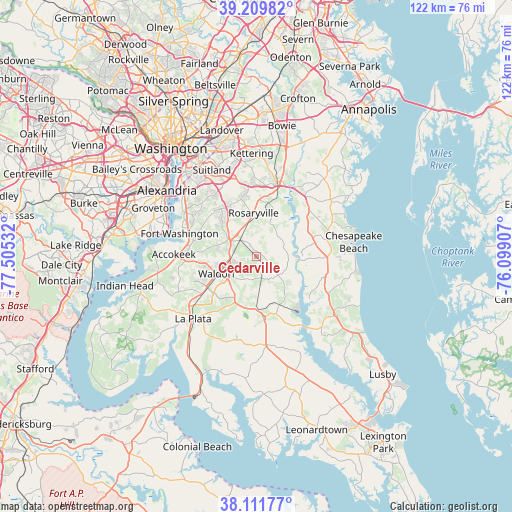
Cedarville GPS coordinates[2]
38° 39' 46.44" North, 76° 48' 7.884" West
| Map corner | latitude | longitude |
|---|---|---|
| Upper-left | 39.20982°, | -77.50532° |
| Center: | 38.6629°, | -76.80219° |
| Lower-right: | 38.11177°, | -76.09907° |
| Map W x H: | 122.1×122.1 km | = 75.9×75.9mi |
| max Lat: | 71.29058° ⇑57.7% North |
| Cedarville: | 38.6629° |
| min Lat: | ⇓42.3% South 19.06759° |
| min Long | Cedarville | max Long |
| -171.73463° | -76.80219° | -66.98998° |
| W 81.5%⇐ | ⇒18.5% E |
Elevation
Elevation of Cedarville is 64 m = 210 ft, and this is 230.8 m = 757 ft below average elevation for this country.
| Max E: |
3189 m = 10463 ft | 76.3% |
| Avg. | 294.8 m = 967 ft | |
| Cedarville | 64 m = 210 ft | |
Min E: |
-60 m = -197 ft | 23.7% |
See also: United States elevation on elevation.city.
Geographical zone
Cedarville is located in North temperate zone (between Tropic of Cancer and the Arctic Circle). Distance of this Northern Tropic circle is 1693 km =1052 mi to South.| Distance of | km | miles | from Cedarville |
|---|---|---|---|
| North Pole | 5708.2 | 3546.9 | to North |
| Arctic Circle | 3102.3 | 1927.7 | to North |
| Tropic Cancer | 1693 | 1052 | to South |
| Equator | 4298.9 | 2671.2 | to South |


Nearby cities:
15 places around Cedarville: (largest is in red/bold)
• Aquasco
10.9 km =6.8 mi,  142°
142°
• Baden
2.2 km =1.4 mi,  100°
100°
• Brandywine
5.5 km =3.4 mi,  313°
313°
• Bryantown
12.5 km =7.8 mi,  196°
196°
• Clinton
14.1 km =8.8 mi,  323°
323°
• Croom
10.5 km =6.5 mi,  18°
18°
• Dunkirk
13.9 km =8.6 mi,  61°
61°
• Dunkirk Town Center
14 km =8.7 mi, 62°
• Hughesville
14.6 km =9.1 mi,  173°
173°
• Marlton
12.4 km =7.7 mi,  4°
4°
• Queenland
15.9 km =9.9 mi, 3°
• Rosaryville
10.5 km =6.5 mi,  356°
356°
• Saint Charles
13.6 km =8.5 mi,  240°
240°
• St. Charles
12.3 km =7.6 mi, 239°
• Waldorf
12.6 km =7.8 mi,  250°
250°
Sources, notices
• [Note1] Compared only with cities in United States existing in our database
• [Src1] Map data: © OpenStreetMap contributors (CC-BY-SA)
• [Src2] Other city data from geonames.org with taken over terms of usage.
• [Src3] Geographical zone / Annual Mean Temperature by Robert A. Rohde @ Wikipedia
