Bryantown geodata
Bryantown (Maryland) is a populated place; located in United States in America/New_York (GMT-4) time zone. With population of 655 people, there are 19138 cities with bigger population in this country. Compared to other cities in United States, 58.4% of cities are located further ↑North; 81.3% of cities are located further ←West and 79.7% of cities have higher elevation than Bryantown. Note1


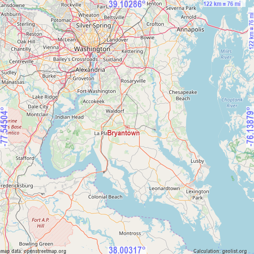
Bryantown GPS coordinates[2]
38° 33' 18.432" North, 76° 50' 30.876" West
| Map corner | latitude | longitude |
|---|---|---|
| Upper-left | 39.10286°, | -77.54504° |
| Center: | 38.55512°, | -76.84191° |
| Lower-right: | 38.00317°, | -76.13879° |
| Map W x H: | 122.3×122.3 km | = 76×76mi |
| max Lat: | 71.29058° ⇑58.4% North |
| Bryantown: | 38.55512° |
| min Lat: | ⇓41.6% South 19.06759° |
| min Long | Bryantown | max Long |
| -171.73463° | -76.84191° | -66.98998° |
| W 81.3%⇐ | ⇒18.7% E |
Elevation
Elevation of Bryantown is 48 m = 157 ft, and this is 246.8 m = 810 ft below average elevation for this country.
| Max E: |
3189 m = 10463 ft | 79.7% |
| Avg. | 294.8 m = 967 ft | |
| Bryantown | 48 m = 157 ft | |
Min E: |
-60 m = -197 ft | 20.3% |
See also: United States elevation on elevation.city.
Geographical zone
Bryantown is located in North temperate zone (between Tropic of Cancer and the Arctic Circle). Distance of this Northern Tropic circle is 1681 km =1044.5 mi to South.| Distance of | km | miles | from Bryantown |
|---|---|---|---|
| North Pole | 5720.1 | 3554.3 | to North |
| Arctic Circle | 3114.2 | 1935.1 | to North |
| Tropic Cancer | 1681 | 1044.5 | to South |
| Equator | 4286.9 | 2663.8 | to South |


Nearby cities:
15 places around Bryantown: (largest is in red/bold)
• Accokeek
20.5 km =12.7 mi,  307°
307°
• Aquasco
10.7 km =6.6 mi,  71°
71°
• Baden
12.9 km =8 mi,  25°
25°
• Bennsville
16 km =9.9 mi,  292°
292°
• Brandywine
15.8 km =9.8 mi,  358°
358°
• Cedarville
12.5 km =7.8 mi,  16°
16°
• Charlotte Hall
9.9 km =6.2 mi,  146°
146°
• Golden Beach
15.7 km =9.8 mi,  117°
117°
• Hughesville
5.6 km =3.5 mi, 116°
• La Plata
11.9 km =7.4 mi,  256°
256°
• Mechanicsville
15.1 km =9.4 mi, 145°
• Pomfret
16.6 km =10.3 mi,  278°
278°
• Saint Charles
10 km =6.2 mi,  302°
302°
• St. Charles
9.2 km =5.7 mi, 308°
• Waldorf
11.4 km =7.1 mi, 312°
Sources, notices
• [Note1] Compared only with cities in United States existing in our database
• [Src1] Map data: © OpenStreetMap contributors (CC-BY-SA)
• [Src2] Other city data from geonames.org with taken over terms of usage.
• [Src3] Geographical zone / Annual Mean Temperature by Robert A. Rohde @ Wikipedia
