Germantown geodata
Germantown (Maryland) is a populated place; located in United States in America/New_York (GMT-4) time zone. With population of 86,395 people, there are 445 cities with bigger population in this country. Compared to other cities in United States, 53.3% of cities are located further ↑North; 79.6% of cities are located further ←West and 63.3% of cities have higher elevation than Germantown. Note1


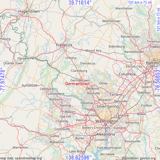
Germantown GPS coordinates[2]
39° 10' 23.376" North, 77° 16' 17.94" West
| Map corner | latitude | longitude |
|---|---|---|
| Upper-left | 39.71614°, | -77.97478° |
| Center: | 39.17316°, | -77.27165° |
| Lower-right: | 38.62596°, | -76.56853° |
| Map W x H: | 121.2×121.2 km | = 75.3×75.3mi |
| max Lat: | 71.29058° ⇑53.3% North |
| Germantown: | 39.17316° |
| min Lat: | ⇓46.7% South 19.06759° |
| min Long | Germantown | max Long |
| -171.73463° | -77.27165° | -66.98998° |
| W 79.6%⇐ | ⇒20.4% E |
Elevation
Elevation of Germantown is 137 m = 449 ft, and this is 157.8 m = 518 ft below average elevation for this country.
| Max E: |
3189 m = 10463 ft | 63.3% |
| Avg. | 294.8 m = 967 ft | |
| Germantown | 137 m = 449 ft | |
Min E: |
-60 m = -197 ft | 36.7% |
See also: Germantown elevation on elevation.city.
Geographical zone
Germantown is located in North temperate zone (between Tropic of Cancer and the Arctic Circle). Distance of this Northern Tropic circle is 1749.7 km =1087.2 mi to South.| Distance of | km | miles | from Germantown |
|---|---|---|---|
| North Pole | 5651.4 | 3511.6 | to North |
| Arctic Circle | 3045.5 | 1892.4 | to North |
| Tropic Cancer | 1749.7 | 1087.2 | to South |
| Equator | 4355.6 | 2706.4 | to South |


Nearby cities:
15 places around Germantown: (largest is in red/bold)
• Clarksburg
7.3 km =4.5 mi,  354°
354°
• Damascus
14.1 km =8.8 mi,  24°
24°
• Darnestown
7.9 km =4.9 mi,  192°
192°
• Derwood
11.4 km =7.1 mi,  123°
123°
• Gaithersburg
6.9 km =4.3 mi, 118°
• Green Valley
15.3 km =9.5 mi, 351°
• Lowes Island
14.4 km =8.9 mi,  208°
208°
• Montgomery Village
6.6 km =4.1 mi,  86°
86°
• North Potomac
10.1 km =6.3 mi,  176°
176°
• Poolesville
12.9 km =8 mi,  256°
256°
• Redland
11.4 km =7.1 mi,  105°
105°
• Rockville
14.3 km =8.9 mi,  134°
134°
• Sugarland Run
17.5 km =10.9 mi, 210°
• Travilah
11.6 km =7.2 mi, 176°
• Washington Grove
9.1 km =5.7 mi, 114°
Sources, notices
• [Note1] Compared only with cities in United States existing in our database
• [Src1] Map data: © OpenStreetMap contributors (CC-BY-SA)
• [Src2] Other city data from geonames.org with taken over terms of usage.
• [Src3] Geographical zone / Annual Mean Temperature by Robert A. Rohde @ Wikipedia
