Travilah geodata
Travilah (Maryland) is a populated place; located in United States in America/New_York (GMT-4) time zone. With population of 12,159 people, there are 3854 cities with bigger population in this country. Compared to other cities in United States, 54.2% of cities are located further ↑North; 79.6% of cities are located further ←West and 68.9% of cities have higher elevation than Travilah. Note1


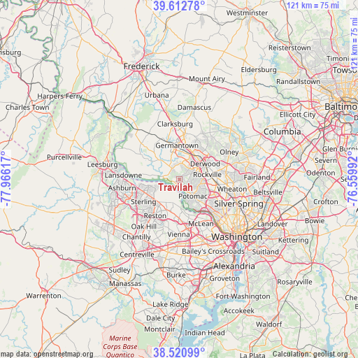
Travilah GPS coordinates[2]
39° 4' 8.4" North, 77° 15' 46.944" West
| Map corner | latitude | longitude |
|---|---|---|
| Upper-left | 39.61278°, | -77.96617° |
| Center: | 39.069°, | -77.26304° |
| Lower-right: | 38.52099°, | -76.55992° |
| Map W x H: | 121.4×121.4 km | = 75.4×75.4mi |
| max Lat: | 71.29058° ⇑54.2% North |
| Travilah: | 39.069° |
| min Lat: | ⇓45.8% South 19.06759° |
| min Long | Travilah | max Long |
| -171.73463° | -77.26304° | -66.98998° |
| W 79.6%⇐ | ⇒20.4% E |
Elevation
Elevation of Travilah is 107 m = 351 ft, and this is 187.8 m = 616 ft below average elevation for this country.
| Max E: |
3189 m = 10463 ft | 68.9% |
| Avg. | 294.8 m = 967 ft | |
| Travilah | 107 m = 351 ft | |
Min E: |
-60 m = -197 ft | 31.1% |
See also: United States elevation on elevation.city.
Geographical zone
Travilah is located in North temperate zone (between Tropic of Cancer and the Arctic Circle). Distance of this Northern Tropic circle is 1738.1 km =1080 mi to South.| Distance of | km | miles | from Travilah |
|---|---|---|---|
| North Pole | 5663 | 3518.8 | to North |
| Arctic Circle | 3057.1 | 1899.6 | to North |
| Tropic Cancer | 1738.1 | 1080 | to South |
| Equator | 4344.1 | 2699.3 | to South |


Nearby cities:
15 places around Travilah: (largest is in red/bold)
• Darnestown
4.5 km =2.8 mi,  327°
327°
• Derwood
10.3 km =6.4 mi,  58°
58°
• Dranesville
10.4 km =6.5 mi,  223°
223°
• Gaithersburg
9.8 km =6.1 mi,  32°
32°
• Germantown
11.6 km =7.2 mi,  356°
356°
• Great Falls
8.2 km =5.1 mi,  195°
195°
• Lowes Island
7.8 km =4.8 mi,  262°
262°
• Montgomery Village
13.3 km =8.3 mi, 26°
• North Bethesda
12.7 km =7.9 mi,  102°
102°
• North Potomac
1.6 km =1 mi,  353°
353°
• Potomac
7.4 km =4.6 mi,  140°
140°
• Reston
13 km =8.1 mi,  211°
211°
• Rockville
9.7 km =6 mi,  80°
80°
• Sugarland Run
10.3 km =6.4 mi,  250°
250°
• Washington Grove
10.9 km =6.8 mi,  43°
43°
Sources, notices
• [Note1] Compared only with cities in United States existing in our database
• [Src1] Map data: © OpenStreetMap contributors (CC-BY-SA)
• [Src2] Other city data from geonames.org with taken over terms of usage.
• [Src3] Geographical zone / Annual Mean Temperature by Robert A. Rohde @ Wikipedia
