Darnestown geodata
Darnestown (Maryland) is a populated place; located in United States in America/New_York (GMT-4) time zone. With population of 6,802 people, there are 5922 cities with bigger population in this country. Compared to other cities in United States, 53.9% of cities are located further ↑North; 79.5% of cities are located further ←West and 63.8% of cities have higher elevation than Darnestown. Note1


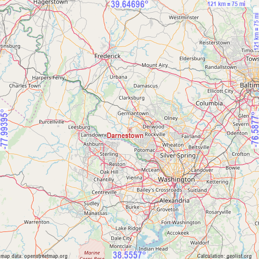
Darnestown GPS coordinates[2]
39° 6' 12.384" North, 77° 17' 26.952" West
| Map corner | latitude | longitude |
|---|---|---|
| Upper-left | 39.64696°, | -77.99395° |
| Center: | 39.10344°, | -77.29082° |
| Lower-right: | 38.5557°, | -76.5877° |
| Map W x H: | 121.3×121.3 km | = 75.4×75.4mi |
| max Lat: | 71.29058° ⇑53.9% North |
| Darnestown: | 39.10344° |
| min Lat: | ⇓46.1% South 19.06759° |
| min Long | Darnestown | max Long |
| -171.73463° | -77.29082° | -66.98998° |
| W 79.5%⇐ | ⇒20.5% E |
Elevation
Elevation of Darnestown is 134 m = 440 ft, and this is 160.8 m = 528 ft below average elevation for this country.
| Max E: |
3189 m = 10463 ft | 63.8% |
| Avg. | 294.8 m = 967 ft | |
| Darnestown | 134 m = 440 ft | |
Min E: |
-60 m = -197 ft | 36.2% |
See also: United States elevation on elevation.city.
Geographical zone
Darnestown is located in North temperate zone (between Tropic of Cancer and the Arctic Circle). Distance of this Northern Tropic circle is 1742 km =1082.4 mi to South.| Distance of | km | miles | from Darnestown |
|---|---|---|---|
| North Pole | 5659.2 | 3516.5 | to North |
| Arctic Circle | 3053.3 | 1897.2 | to North |
| Tropic Cancer | 1742 | 1082.4 | to South |
| Equator | 4347.9 | 2701.7 | to South |


Nearby cities:
15 places around Darnestown: (largest is in red/bold)
• Countryside
12.7 km =7.9 mi,  236°
236°
• Derwood
11.3 km =7 mi,  82°
82°
• Dranesville
12.4 km =7.7 mi,  202°
202°
• Gaithersburg
8.9 km =5.5 mi,  60°
60°
• Germantown
7.9 km =4.9 mi,  12°
12°
• Great Falls
11.7 km =7.3 mi,  178°
178°
• Lowes Island
7.2 km =4.5 mi,  227°
227°
• Montgomery Village
11.6 km =7.2 mi,  45°
45°
• North Potomac
3.2 km =2 mi,  135°
135°
• Poolesville
11.9 km =7.4 mi,  293°
293°
• Potomac
11.8 km =7.3 mi, 143°
• Rockville
12.1 km =7.5 mi,  100°
100°
• Sugarland Run
10.3 km =6.4 mi,  224°
224°
• Travilah
4.5 km =2.8 mi,  147°
147°
• Washington Grove
10.8 km =6.7 mi,  67°
67°
Sources, notices
• [Note1] Compared only with cities in United States existing in our database
• [Src1] Map data: © OpenStreetMap contributors (CC-BY-SA)
• [Src2] Other city data from geonames.org with taken over terms of usage.
• [Src3] Geographical zone / Annual Mean Temperature by Robert A. Rohde @ Wikipedia
