Hagerstown geodata
Hagerstown (Maryland) is a seat of a second-order administrative division; located in United States in America/New_York (GMT-4) time zone. With population of 40,432 people, there are 1198 cities with bigger population in this country. Compared to other cities in United States, 50.2% of cities are located further ↓South; 78.4% of cities are located further ←West and 57.5% of cities have higher elevation than Hagerstown. Note1


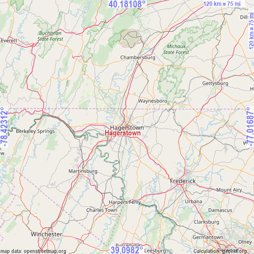
Hagerstown GPS coordinates[2]
39° 38' 30.336" North, 77° 43' 11.964" West
| Map corner | latitude | longitude |
|---|---|---|
| Upper-left | 40.18108°, | -78.42312° |
| Center: | 39.64176°, | -77.71999° |
| Lower-right: | 39.0982°, | -77.01687° |
| Map W x H: | 120.4×120.4 km | = 74.8×74.8mi |
| max Lat: | 71.29058° ⇑49.8% North |
| Hagerstown: | 39.64176° |
| min Lat: | ⇓50.2% South 19.06759° |
| min Long | Hagerstown | max Long |
| -171.73463° | -77.71999° | -66.98998° |
| W 78.4%⇐ | ⇒21.6% E |
Elevation
Elevation of Hagerstown is 168 m = 551 ft, and this is 126.8 m = 416 ft below average elevation for this country.
| Max E: |
3189 m = 10463 ft | 57.5% |
| Avg. | 294.8 m = 967 ft | |
| Hagerstown | 168 m = 551 ft | |
Min E: |
-60 m = -197 ft | 42.5% |
See also: Hagerstown elevation on elevation.city.
Geographical zone
Hagerstown is located in North temperate zone (between Tropic of Cancer and the Arctic Circle). Distance of this Northern Tropic circle is 1801.8 km =1119.6 mi to South.| Distance of | km | miles | from Hagerstown |
|---|---|---|---|
| North Pole | 5599.3 | 3479.2 | to North |
| Arctic Circle | 2993.4 | 1860 | to North |
| Tropic Cancer | 1801.8 | 1119.6 | to South |
| Equator | 4407.8 | 2738.9 | to South |


Nearby cities:
15 places around Hagerstown: (largest is in red/bold)
• Cavetown
11.5 km =7.1 mi,  88°
88°
• Fairplay
11.9 km =7.4 mi,  191°
191°
• Fountainhead-Orchard Hills
5 km =3.1 mi,  0°
0°
• Funkstown
3.9 km =2.4 mi,  159°
159°
• Halfway
4.1 km =2.5 mi,  234°
234°
• Leitersburg
10.1 km =6.3 mi,  55°
55°
• Maugansville
6.1 km =3.8 mi,  339°
339°
• Mount Aetna
9.3 km =5.8 mi,  118°
118°
• Mount Lena
12.1 km =7.5 mi,  139°
139°
• Paramount-Long Meadow
4.9 km =3 mi,  28°
28°
• Robinwood
5.4 km =3.4 mi,  95°
95°
• Saint James
9.4 km =5.8 mi,  200°
200°
• State Line
9.2 km =5.7 mi,  357°
357°
• Williamsport
9.8 km =6.1 mi,  242°
242°
• Wilson-Conococheague
9.6 km =6 mi,  277°
277°
Sources, notices
• [Note1] Compared only with cities in United States existing in our database
• [Src1] Map data: © OpenStreetMap contributors (CC-BY-SA)
• [Src2] Other city data from geonames.org with taken over terms of usage.
• [Src3] Geographical zone / Annual Mean Temperature by Robert A. Rohde @ Wikipedia
