Paramount-Long Meadow geodata
Paramount-Long Meadow (Maryland) is a populated place; located in United States in America/New_York (GMT-4) time zone. With population of 2,571 people, there are 10453 cities with bigger population in this country. Compared to other cities in United States, 50.5% of cities are located further ↓South; 78.4% of cities are located further ←West and 54.5% of cities have higher elevation than Paramount-Long Meadow. Note1


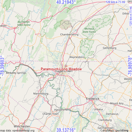
Paramount-Long Meadow GPS coordinates[2]
39° 40' 49.512" North, 77° 41' 34.44" West
| Map corner | latitude | longitude |
|---|---|---|
| Upper-left | 40.21943°, | -78.39603° |
| Center: | 39.68042°, | -77.6929° |
| Lower-right: | 39.13716°, | -76.98978° |
| Map W x H: | 120.3×120.3 km | = 74.8×74.8mi |
| max Lat: | 71.29058° ⇑49.5% North |
| Paramount-Long Meadow: | 39.68042° |
| min Lat: | ⇓50.5% South 19.06759° |
| min Long | Paramount-Long | max Long |
| -171.73463° | -77.6929° | -66.98998° |
| W 78.4%⇐ | ⇒21.6% E |
Elevation
Elevation of Paramount-Long Meadow is 182 m = 597 ft, and this is 112.8 m = 370 ft below average elevation for this country.
| Max E: |
3189 m = 10463 ft | 54.5% |
| Avg. | 294.8 m = 967 ft | |
| Paramount-Long Meadow | 182 m = 597 ft | |
Min E: |
-60 m = -197 ft | 45.5% |
See also: United States elevation on elevation.city.
Geographical zone
Paramount-Long Meadow is located in North temperate zone (between Tropic of Cancer and the Arctic Circle). Distance of this Northern Tropic circle is 1806.1 km =1122.3 mi to South.| Distance of | km | miles | from Paramount-Long Meadow |
|---|---|---|---|
| North Pole | 5595 | 3476.6 | to North |
| Arctic Circle | 2989.1 | 1857.3 | to North |
| Tropic Cancer | 1806.1 | 1122.3 | to South |
| Equator | 4412 | 2741.5 | to South |


Nearby cities:
15 places around Paramount-Long Meadow: (largest is in red/bold)
• Cavetown
10 km =6.2 mi,  113°
113°
• Fountainhead-Orchard Hills
2.3 km =1.4 mi,  286°
286°
• Funkstown
8 km =5 mi,  187°
187°
• Greencastle
12.6 km =7.8 mi,  346°
346°
• Hagerstown
4.9 km =3 mi,  208°
208°
• Halfway
8.7 km =5.4 mi,  220°
220°
• Leitersburg
6.2 km =3.9 mi,  77°
77°
• Maugansville
4.6 km =2.9 mi, 287°
• Mount Aetna
10.5 km =6.5 mi,  145°
145°
• Robinwood
5.7 km =3.5 mi, 147°
• Smithsburg
10.7 km =6.6 mi, 105°
• State Line
5.6 km =3.5 mi,  331°
331°
• Wayne Heights
13.8 km =8.6 mi,  59°
59°
• Waynesboro
12.9 km =8 mi,  49°
49°
• Wilson-Conococheague
12.2 km =7.6 mi,  255°
255°
Sources, notices
• [Note1] Compared only with cities in United States existing in our database
• [Src1] Map data: © OpenStreetMap contributors (CC-BY-SA)
• [Src2] Other city data from geonames.org with taken over terms of usage.
• [Src3] Geographical zone / Annual Mean Temperature by Robert A. Rohde @ Wikipedia
