Maugansville geodata
Maugansville (Maryland) is a populated place; located in United States in America/New_York (GMT-4) time zone. With population of 3,071 people, there are 9521 cities with bigger population in this country. Compared to other cities in United States, 50.6% of cities are located further ↓South; 78.3% of cities are located further ←West and 52.8% of cities have higher elevation than Maugansville. Note1


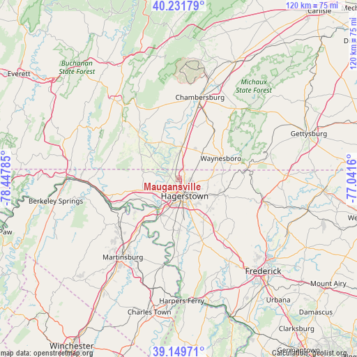
Maugansville GPS coordinates[2]
39° 41' 34.332" North, 77° 44' 40.992" West
| Map corner | latitude | longitude |
|---|---|---|
| Upper-left | 40.23179°, | -78.44785° |
| Center: | 39.69287°, | -77.74472° |
| Lower-right: | 39.14971°, | -77.0416° |
| Map W x H: | 120.3×120.3 km | = 74.8×74.8mi |
| max Lat: | 71.29058° ⇑49.4% North |
| Maugansville: | 39.69287° |
| min Lat: | ⇓50.6% South 19.06759° |
| min Long | Maugansville | max Long |
| -171.73463° | -77.74472° | -66.98998° |
| W 78.3%⇐ | ⇒21.7% E |
Elevation
Elevation of Maugansville is 188 m = 617 ft, and this is 106.8 m = 350 ft below average elevation for this country.
| Max E: |
3189 m = 10463 ft | 52.8% |
| Avg. | 294.8 m = 967 ft | |
| Maugansville | 188 m = 617 ft | |
Min E: |
-60 m = -197 ft | 47.2% |
See also: United States elevation on elevation.city.
Geographical zone
Maugansville is located in North temperate zone (between Tropic of Cancer and the Arctic Circle). Distance of this Northern Tropic circle is 1807.5 km =1123.1 mi to South.| Distance of | km | miles | from Maugansville |
|---|---|---|---|
| North Pole | 5593.6 | 3475.7 | to North |
| Arctic Circle | 2987.7 | 1856.5 | to North |
| Tropic Cancer | 1807.5 | 1123.1 | to South |
| Equator | 4413.4 | 2742.4 | to South |


Nearby cities:
15 places around Maugansville: (largest is in red/bold)
• Cavetown
14.6 km =9.1 mi,  111°
111°
• Fountainhead-Orchard Hills
2.3 km =1.4 mi, 108°
• Funkstown
9.9 km =6.2 mi,  159°
159°
• Greencastle
10.9 km =6.8 mi,  7°
7°
• Hagerstown
6.1 km =3.8 mi, 159°
• Halfway
8.1 km =5 mi,  188°
188°
• Leitersburg
10.4 km =6.5 mi,  90°
90°
• Mount Aetna
14.4 km =8.9 mi,  134°
134°
• Paramount-Long Meadow
4.6 km =2.9 mi, 107°
• Robinwood
9.7 km =6 mi, 129°
• Saint James
14.5 km =9 mi,  184°
184°
• Smithsburg
15.3 km =9.5 mi, 106°
• State Line
4 km =2.5 mi,  26°
26°
• Williamsport
12.1 km =7.5 mi,  212°
212°
• Wilson-Conococheague
8.6 km =5.3 mi,  239°
239°
Sources, notices
• [Note1] Compared only with cities in United States existing in our database
• [Src1] Map data: © OpenStreetMap contributors (CC-BY-SA)
• [Src2] Other city data from geonames.org with taken over terms of usage.
• [Src3] Geographical zone / Annual Mean Temperature by Robert A. Rohde @ Wikipedia
