Owings Mills geodata
Owings Mills (Maryland) is a populated place; located in United States in America/New_York (GMT-4) time zone. With population of 30,622 people, there are 1625 cities with bigger population in this country. Compared to other cities in United States, 51.4% of cities are located further ↑North; 81.6% of cities are located further ←West and 60.5% of cities have higher elevation than Owings Mills. Note1


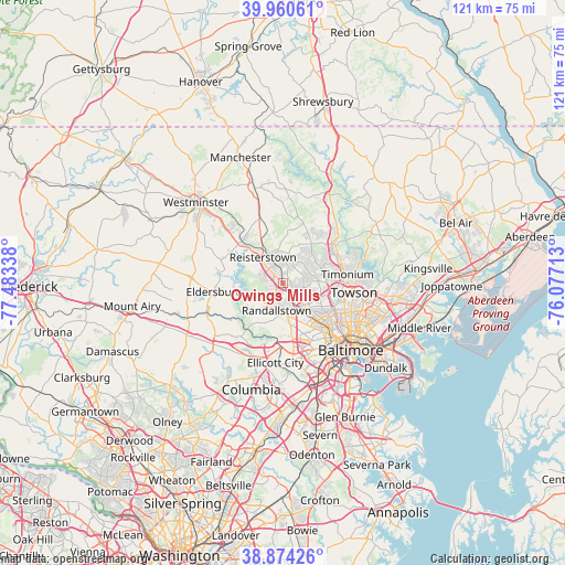
Owings Mills GPS coordinates[2]
39° 25' 10.38" North, 76° 46' 48.9" West
| Map corner | latitude | longitude |
|---|---|---|
| Upper-left | 39.96061°, | -77.48338° |
| Center: | 39.41955°, | -76.78025° |
| Lower-right: | 38.87426°, | -76.07713° |
| Map W x H: | 120.8×120.8 km | = 75.1×75.1mi |
| max Lat: | 71.29058° ⇑51.4% North |
| Owings Mills: | 39.41955° |
| min Lat: | ⇓48.6% South 19.06759° |
| min Long | Owings Mills | max Long |
| -171.73463° | -76.78025° | -66.98998° |
| W 81.6%⇐ | ⇒18.4% E |
Elevation
Elevation of Owings Mills is 152 m = 499 ft, and this is 142.8 m = 469 ft below average elevation for this country.
| Max E: |
3189 m = 10463 ft | 60.5% |
| Avg. | 294.8 m = 967 ft | |
| Owings Mills | 152 m = 499 ft | |
Min E: |
-60 m = -197 ft | 39.5% |
See also: United States elevation on elevation.city.
Geographical zone
Owings Mills is located in North temperate zone (between Tropic of Cancer and the Arctic Circle). Distance of this Northern Tropic circle is 1777.1 km =1104.2 mi to South.| Distance of | km | miles | from Owings Mills |
|---|---|---|---|
| North Pole | 5624 | 3494.6 | to North |
| Arctic Circle | 3018.1 | 1875.4 | to North |
| Tropic Cancer | 1777.1 | 1104.2 | to South |
| Equator | 4383 | 2723.5 | to South |


Nearby cities:
15 places around Owings Mills: (largest is in red/bold)
• Arlington
11.5 km =7.1 mi,  133°
133°
• Cockeysville
13.6 km =8.5 mi,  59°
59°
• Eldersburg
14.7 km =9.1 mi,  263°
263°
• Garrison
2.3 km =1.4 mi, 131°
• Hunt Valley
14.9 km =9.3 mi,  53°
53°
• Lochearn
10.1 km =6.3 mi,  150°
150°
• Lutherville
13.2 km =8.2 mi,  89°
89°
• Lutherville-Timonium
14.7 km =9.1 mi,  81°
81°
• Mays Chapel
11.3 km =7 mi, 82°
• Milford Mill
8 km =5 mi,  173°
173°
• Pikesville
7.1 km =4.4 mi,  135°
135°
• Randallstown
5.9 km =3.7 mi,  192°
192°
• Reisterstown
7.1 km =4.4 mi,  321°
321°
• Timonium
13.9 km =8.6 mi, 81°
• Woodlawn
11.6 km =7.2 mi,  157°
157°
Sources, notices
• [Note1] Compared only with cities in United States existing in our database
• [Src1] Map data: © OpenStreetMap contributors (CC-BY-SA)
• [Src2] Other city data from geonames.org with taken over terms of usage.
• [Src3] Geographical zone / Annual Mean Temperature by Robert A. Rohde @ Wikipedia
