Upper Marlboro geodata
Upper Marlboro (Maryland) is a seat of a second-order administrative division; located in United States in America/New_York (GMT-4) time zone. With population of 667 people, there are 19002 cities with bigger population in this country. Compared to other cities in United States, 56.4% of cities are located further ↑North; 81.7% of cities are located further ←West and 89.5% of cities have higher elevation than Upper Marlboro. Note1


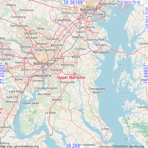
Upper Marlboro GPS coordinates[2]
38° 48' 57.42" North, 76° 44' 58.884" West
| Map corner | latitude | longitude |
|---|---|---|
| Upper-left | 39.36169°, | -77.45282° |
| Center: | 38.81595°, | -76.74969° |
| Lower-right: | 38.266°, | -76.04657° |
| Map W x H: | 121.8×121.8 km | = 75.7×75.7mi |
| max Lat: | 71.29058° ⇑56.4% North |
| Upper Marlboro: | 38.81595° |
| min Lat: | ⇓43.6% South 19.06759° |
| min Long | Upper Marlboro | max Long |
| -171.73463° | -76.74969° | -66.98998° |
| W 81.7%⇐ | ⇒18.3% E |
Elevation
Elevation of Upper Marlboro is 17 m = 56 ft, and this is 277.8 m = 911 ft below average elevation for this country.
| Max E: |
3189 m = 10463 ft | 89.5% |
| Avg. | 294.8 m = 967 ft | |
| Upper Marlboro | 17 m = 56 ft | |
Min E: |
-60 m = -197 ft | 10.5% |
See also: United States elevation on elevation.city.
Geographical zone
Upper Marlboro is located in North temperate zone (between Tropic of Cancer and the Arctic Circle). Distance of this Northern Tropic circle is 1710 km =1062.5 mi to South.| Distance of | km | miles | from Upper Marlboro |
|---|---|---|---|
| North Pole | 5691.1 | 3536.3 | to North |
| Arctic Circle | 3085.2 | 1917.1 | to North |
| Tropic Cancer | 1710 | 1062.5 | to South |
| Equator | 4315.9 | 2681.8 | to South |


Nearby cities:
15 places around Upper Marlboro: (largest is in red/bold)
• Andrews AFB
10.9 km =6.8 mi,  263°
263°
• Brock Hall
3.9 km =2.4 mi,  345°
345°
• Croom
7.1 km =4.4 mi,  189°
189°
• Forestville
11.3 km =7 mi,  286°
286°
• Greater Upper Marlboro
1.7 km =1.1 mi,  4°
4°
• Kettering
9.5 km =5.9 mi,  323°
323°
• Largo
11.4 km =7.1 mi, 322°
• Marlboro Meadows
3.8 km =2.4 mi,  53°
53°
• Marlboro Village
2.4 km =1.5 mi,  313°
313°
• Marlton
5.9 km =3.7 mi,  216°
216°
• Mellwood
6.5 km =4 mi, 264°
• Queen Anne
11.1 km =6.9 mi,  33°
33°
• Queenland
3.8 km =2.4 mi,  251°
251°
• Rosaryville
8.4 km =5.2 mi, 218°
• Westphalia
6.2 km =3.9 mi,  301°
301°
Sources, notices
• [Note1] Compared only with cities in United States existing in our database
• [Src1] Map data: © OpenStreetMap contributors (CC-BY-SA)
• [Src2] Other city data from geonames.org with taken over terms of usage.
• [Src3] Geographical zone / Annual Mean Temperature by Robert A. Rohde @ Wikipedia
