Bull Creek geodata
Bull Creek (Missouri) is a populated place; located in United States in America/Chicago (GMT-5) time zone. With population of 595 people, there are 19757 cities with bigger population in this country. Compared to other cities in United States, 67.2% of cities are located further ↑North; 66.7% of cities are located further →East and 55.8% of cities have lower elevation than Bull Creek. Note1


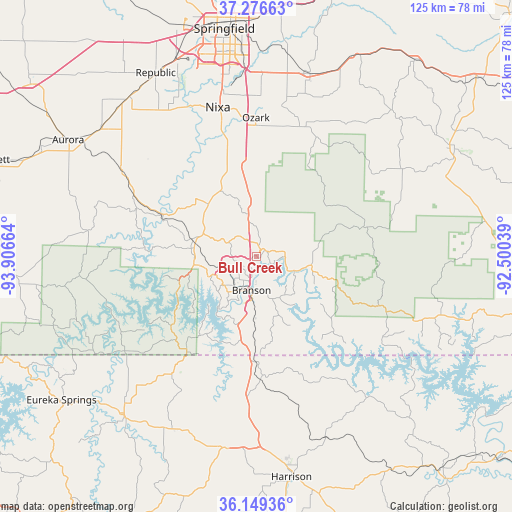
Bull Creek GPS coordinates[2]
36° 42' 54.216" North, 93° 12' 12.636" West
| Map corner | latitude | longitude |
|---|---|---|
| Upper-left | 37.27663°, | -93.90664° |
| Center: | 36.71506°, | -93.20351° |
| Lower-right: | 36.14936°, | -92.50039° |
| Map W x H: | 125.3×125.3 km | = 77.9×77.9mi |
| max Lat: | 71.29058° ⇑67.2% North |
| Bull Creek: | 36.71506° |
| min Lat: | ⇓32.8% South 19.06759° |
| min Long | Bull Creek | max Long |
| -171.73463° | -93.20351° | -66.98998° |
| W 33.3%⇐ | ⇒66.7% E |
Elevation
Elevation of Bull Creek is 222 m = 728 ft, and this is 72.8 m = 239 ft below average elevation for this country.
| Max E: |
3189 m = 10463 ft | 44.2% |
| Avg. | 294.8 m = 967 ft | |
| Bull Creek | 222 m = 728 ft | |
Min E: |
-60 m = -197 ft | 55.8% |
See also: United States elevation on elevation.city.
Geographical zone
Bull Creek is located in North temperate zone (between Tropic of Cancer and the Arctic Circle). Distance of this Northern Tropic circle is 1476.4 km =917.4 mi to South.| Distance of | km | miles | from Bull Creek |
|---|---|---|---|
| North Pole | 5924.7 | 3681.4 | to North |
| Arctic Circle | 3318.8 | 2062.2 | to North |
| Tropic Cancer | 1476.4 | 917.4 | to South |
| Equator | 4082.3 | 2536.6 | to South |


Nearby cities:
15 places around Bull Creek: (largest is in red/bold)
• Branson
8 km =5 mi,  189°
189°
• Diamond City
37.6 km =23.4 mi,  137°
137°
• Forsyth
8.2 km =5.1 mi,  114°
114°
• Galena
25.5 km =15.8 mi,  293°
293°
• Highlandville
25.2 km =15.7 mi,  344°
344°
• Hollister
10.5 km =6.5 mi, 185°
• Indian Point
15.8 km =9.8 mi,  232°
232°
• Kimberling City
21.1 km =13.1 mi,  244°
244°
• Kissee Mills
14.1 km =8.8 mi,  104°
104°
• Merriam Woods
3.7 km =2.3 mi,  91°
91°
• Nixa
37.4 km =23.2 mi,  347°
347°
• Ozark
34 km =21.1 mi,  359°
359°
• Reeds Spring
16 km =9.9 mi,  283°
283°
• Rockaway Beach
4.3 km =2.7 mi, 114°
• Sparta
33.6 km =20.9 mi,  18°
18°
Sources, notices
• [Note1] Compared only with cities in United States existing in our database
• [Src1] Map data: © OpenStreetMap contributors (CC-BY-SA)
• [Src2] Other city data from geonames.org with taken over terms of usage.
• [Src3] Geographical zone / Annual Mean Temperature by Robert A. Rohde @ Wikipedia
