Galena geodata
Galena (Missouri) is a seat of a second-order administrative division; located in United States in America/Chicago (GMT-5) time zone. With population of 409 people, there are 20934 cities with bigger population in this country. Compared to other cities in United States, 66.9% of cities are located further ↑North; 67.4% of cities are located further →East and 74.5% of cities have lower elevation than Galena. Note1


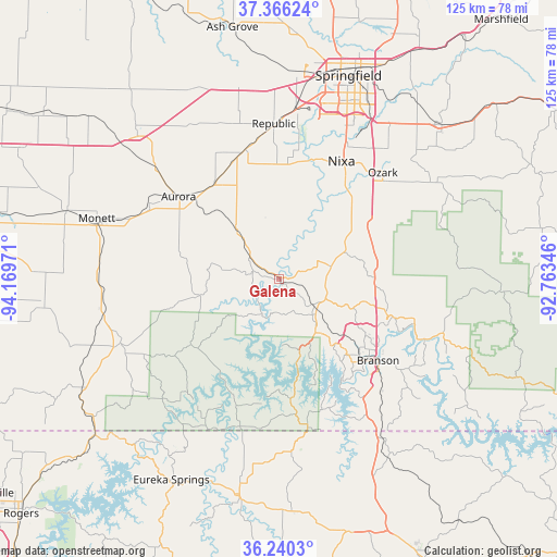
Galena GPS coordinates[2]
36° 48' 19.224" North, 93° 27' 59.688" West
| Map corner | latitude | longitude |
|---|---|---|
| Upper-left | 37.36624°, | -94.16971° |
| Center: | 36.80534°, | -93.46658° |
| Lower-right: | 36.2403°, | -92.76346° |
| Map W x H: | 125.2×125.2 km | = 77.8×77.8mi |
| max Lat: | 71.29058° ⇑66.9% North |
| Galena: | 36.80534° |
| min Lat: | ⇓33.1% South 19.06759° |
| min Long | Galena | max Long |
| -171.73463° | -93.46658° | -66.98998° |
| W 32.6%⇐ | ⇒67.4% E |
Elevation
Elevation of Galena is 310 m = 1017 ft, and this is 15.2 m = 50 ft above average elevation for this country.
| Max E: |
3189 m = 10463 ft | 25.5% |
| Galena | 310 m 1017 ft | |
| Avg. | 294.8 m = 967 ft | |
Min E: |
-60 m = -197 ft | 74.5% |
See also: United States elevation on elevation.city.
Geographical zone
Galena is located in North temperate zone (between Tropic of Cancer and the Arctic Circle). Distance of this Northern Tropic circle is 1486.5 km =923.7 mi to South.| Distance of | km | miles | from Galena |
|---|---|---|---|
| North Pole | 5914.7 | 3675.2 | to North |
| Arctic Circle | 3308.8 | 2056 | to North |
| Tropic Cancer | 1486.5 | 923.7 | to South |
| Equator | 4092.4 | 2542.9 | to South |


Nearby cities:
15 places around Galena: (largest is in red/bold)
• Aurora
29 km =18 mi,  309°
309°
• Billings
30.1 km =18.7 mi,  345°
345°
• Branson
28.5 km =17.7 mi,  129°
129°
• Bull Creek
25.5 km =15.8 mi,  113°
113°
• Clever
25 km =15.5 mi,  358°
358°
• Crane
14.5 km =9 mi,  319°
319°
• Highlandville
21.8 km =13.5 mi,  49°
49°
• Hollister
30.3 km =18.8 mi, 132°
• Indian Point
22.5 km =14 mi,  150°
150°
• Kimberling City
19.6 km =12.2 mi,  166°
166°
• Marionville
26.7 km =16.6 mi,  325°
325°
• Merriam Woods
29 km =18 mi, 110°
• Reeds Spring
10 km =6.2 mi, 128°
• Rockaway Beach
29.8 km =18.5 mi, 113°
• Shell Knob
24.4 km =15.2 mi,  217°
217°
Sources, notices
• [Note1] Compared only with cities in United States existing in our database
• [Src1] Map data: © OpenStreetMap contributors (CC-BY-SA)
• [Src2] Other city data from geonames.org with taken over terms of usage.
• [Src3] Geographical zone / Annual Mean Temperature by Robert A. Rohde @ Wikipedia
