Ozark geodata
Ozark (Missouri) is a seat of a second-order administrative division; located in United States in America/Chicago (GMT-5) time zone. With population of 19,120 people, there are 2633 cities with bigger population in this country. Compared to other cities in United States, 66.1% of cities are located further ↑North; 66.7% of cities are located further →East and 80.6% of cities have lower elevation than Ozark. Note1
Administrative division(s):
- Level 1: Missouri
- Level 2: Christian County
- Level 3: Township of East Finley


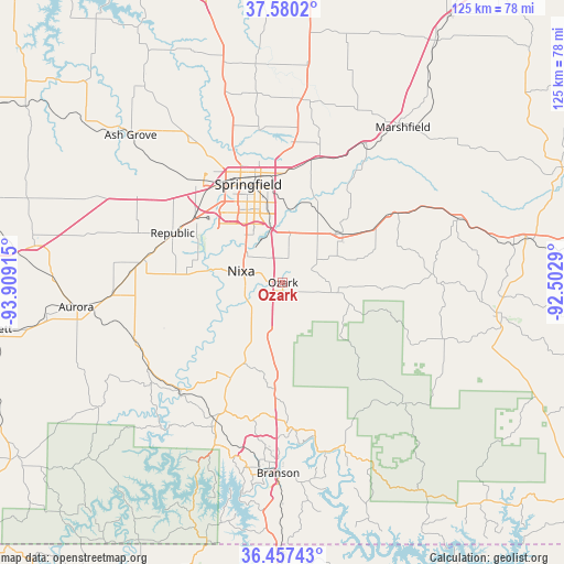
Ozark GPS coordinates[2]
37° 1' 15.204" North, 93° 12' 21.672" West
| Map corner | latitude | longitude |
|---|---|---|
| Upper-left | 37.5802°, | -93.90915° |
| Center: | 37.02089°, | -93.20602° |
| Lower-right: | 36.45743°, | -92.5029° |
| Map W x H: | 124.8×124.8 km | = 77.5×77.5mi |
| max Lat: | 71.29058° ⇑66.1% North |
| Ozark: | 37.02089° |
| min Lat: | ⇓33.9% South 19.06759° |
| min Long | Ozark | max Long |
| -171.73463° | -93.20602° | -66.98998° |
| W 33.3%⇐ | ⇒66.7% E |
Elevation
Elevation of Ozark is 360 m = 1181 ft, and this is 65.2 m = 214 ft above average elevation for this country.
| Max E: |
3189 m = 10463 ft | 19.4% |
| Ozark | 360 m 1181 ft | |
| Avg. | 294.8 m = 967 ft | |
Min E: |
-60 m = -197 ft | 80.6% |
See also: United States elevation on elevation.city.
Geographical zone
Ozark is located in North temperate zone (between Tropic of Cancer and the Arctic Circle). Distance of this Northern Tropic circle is 1510.4 km =938.5 mi to South.| Distance of | km | miles | from Ozark |
|---|---|---|---|
| North Pole | 5890.7 | 3660.3 | to North |
| Arctic Circle | 3284.8 | 2041.1 | to North |
| Tropic Cancer | 1510.4 | 938.5 | to South |
| Equator | 4116.3 | 2557.7 | to South |


Nearby cities:
15 places around Ozark: (largest is in red/bold)
• Battlefield
18 km =11.2 mi,  305°
305°
• Billings
31.2 km =19.4 mi,  279°
279°
• Bull Creek
34 km =21.1 mi,  179°
179°
• Clever
23.7 km =14.7 mi,  272°
272°
• Fordland
28 km =17.4 mi,  57°
57°
• Fremont Hills
6.2 km =3.9 mi,  322°
322°
• Galena
33.3 km =20.7 mi,  224°
224°
• Highlandville
11.8 km =7.3 mi,  214°
214°
• Nixa
8.2 km =5.1 mi,  287°
287°
• Reeds Spring
33.8 km =21 mi, 206°
• Republic
26.7 km =16.6 mi, 294°
• Rogersville
17.1 km =10.6 mi,  51°
51°
• Sparta
11.3 km =7 mi,  101°
101°
• Springfield
23.1 km =14.4 mi,  339°
339°
• Strafford
28.6 km =17.8 mi,  15°
15°
Sources, notices
• [Note1] Compared only with cities in United States existing in our database
• [Src1] Map data: © OpenStreetMap contributors (CC-BY-SA)
• [Src2] Other city data from geonames.org with taken over terms of usage.
• [Src3] Geographical zone / Annual Mean Temperature by Robert A. Rohde @ Wikipedia
