Center geodata
Center (Missouri) is a populated place; located in United States in America/Chicago (GMT-5) time zone. With population of 506 people, there are 20811 cities with bigger population in this country. Compared to other cities in United States, 50.8% of cities are located further ↑North; 63.2% of cities are located further →East and 55.6% of cities have lower elevation than Center. Note1


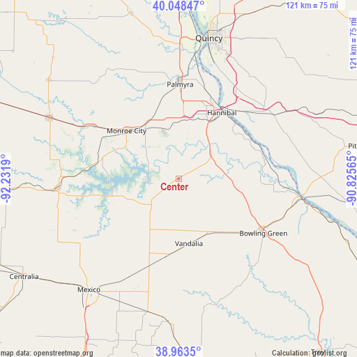
Center GPS coordinates[2]
39° 30' 29.16" North, 91° 31' 43.572" West
| Map corner | latitude | longitude |
|---|---|---|
| Upper-left | 40.04847°, | -92.2319° |
| Center: | 39.5081°, | -91.52877° |
| Lower-right: | 38.9635°, | -90.82565° |
| Map W x H: | 120.6×120.6 km | = 74.9×74.9mi |
| max Lat: | 71.29058° ⇑50.8% North |
| Center: | 39.5081° |
| min Lat: | ⇓49.2% South 19.06759° |
| min Long | Center | max Long |
| -171.73463° | -91.52877° | -66.98998° |
| W 36.8%⇐ | ⇒63.2% E |
Elevation
Elevation of Center is 221 m = 725 ft, and this is 73.8 m = 242 ft below average elevation for this country.
| Max E: |
3189 m = 10463 ft | 44.4% |
| Avg. | 294.8 m = 967 ft | |
| Center | 221 m = 725 ft | |
Min E: |
-60 m = -197 ft | 55.6% |
See also: United States elevation on elevation.city.
Geographical zone
Center is located in North temperate zone (between Tropic of Cancer and the Arctic Circle). Distance of this Northern Tropic circle is 1787 km =1110.4 mi to South.| Distance of | km | miles | from Center |
|---|---|---|---|
| North Pole | 5614.2 | 3488.5 | to North |
| Arctic Circle | 3008.3 | 1869.3 | to North |
| Tropic Cancer | 1787 | 1110.4 | to South |
| Equator | 4392.9 | 2729.6 | to South |


Nearby cities:
15 places around Center: (largest is in red/bold)
• Barry
46.8 km =29.1 mi,  63°
63°
• Bowling Green
34.1 km =21.2 mi,  122°
122°
• Hannibal
26.6 km =16.5 mi,  33°
33°
• Laddonia
31.2 km =19.4 mi,  198°
198°
• Louisiana
41.5 km =25.8 mi,  99°
99°
• Mexico
48.4 km =30.1 mi,  218°
218°
• Monroe City
23.9 km =14.9 mi,  312°
312°
• New London
13.9 km =8.6 mi,  51°
51°
• Palmyra
31.8 km =19.8 mi,  0°
0°
• Paris
40.7 km =25.3 mi,  265°
265°
• Payson
42.2 km =26.2 mi,  35°
35°
• Perry
15.2 km =9.4 mi,  235°
235°
• Quincy
48.6 km =30.2 mi,  12°
12°
• Vandalia
22.2 km =13.8 mi,  171°
171°
• Wellsville
48.6 km =30.2 mi,  184°
184°
Sources, notices
• [Note1] Compared only with cities in United States existing in our database
• [Src1] Map data: © OpenStreetMap contributors (CC-BY-SA)
• [Src2] Other city data from geonames.org with taken over terms of usage.
• [Src3] Geographical zone / Annual Mean Temperature by Robert A. Rohde @ Wikipedia
