Quincy geodata
Quincy (Illinois) is a seat of a second-order administrative division; located in United States in America/Chicago (GMT-5) time zone. With population of 40,780 people, there are 1184 cities with bigger population in this country. Compared to other cities in United States, 52.9% of cities are located further ↓South; 62.9% of cities are located further →East and 57.7% of cities have higher elevation than Quincy. Note1


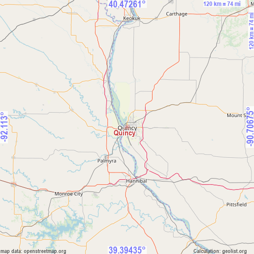
Quincy GPS coordinates[2]
39° 56' 8.16" North, 91° 24' 35.532" West
| Map corner | latitude | longitude |
|---|---|---|
| Upper-left | 40.47261°, | -92.113° |
| Center: | 39.9356°, | -91.40987° |
| Lower-right: | 39.39435°, | -90.70675° |
| Map W x H: | 119.9×119.9 km | = 74.5×74.5mi |
| max Lat: | 71.29058° ⇑47.1% North |
| Quincy: | 39.9356° |
| min Lat: | ⇓52.9% South 19.06759° |
| min Long | Quincy | max Long |
| -171.73463° | -91.40987° | -66.98998° |
| W 37.1%⇐ | ⇒62.9% E |
Elevation
Elevation of Quincy is 167 m = 548 ft, and this is 127.8 m = 419 ft below average elevation for this country.
| Max E: |
3189 m = 10463 ft | 57.7% |
| Avg. | 294.8 m = 967 ft | |
| Quincy | 167 m = 548 ft | |
Min E: |
-60 m = -197 ft | 42.3% |
See also: Quincy elevation on elevation.city.
Geographical zone
Quincy is located in North temperate zone (between Tropic of Cancer and the Arctic Circle). Distance of this Northern Tropic circle is 1834.5 km =1139.9 mi to South.| Distance of | km | miles | from Quincy |
|---|---|---|---|
| North Pole | 5566.6 | 3458.9 | to North |
| Arctic Circle | 2960.8 | 1839.8 | to North |
| Tropic Cancer | 1834.5 | 1139.9 | to South |
| Equator | 4440.4 | 2759.1 | to South |


Nearby cities:
15 places around Quincy: (largest is in red/bold)
• Barry
41.5 km =25.8 mi,  130°
130°
• Camp Point
31.2 km =19.4 mi,  68°
68°
• Canton
27.9 km =17.3 mi,  318°
318°
• Clayton
39.7 km =24.7 mi, 74°
• Golden
38.6 km =24 mi,  59°
59°
• Hannibal
25.6 km =15.9 mi,  170°
170°
• La Grange
14.1 km =8.8 mi,  327°
327°
• Lewistown
38.2 km =23.7 mi,  295°
295°
• Liberty
26.5 km =16.5 mi,  103°
103°
• Mendon
20.1 km =12.5 mi,  32°
32°
• Monticello
32.8 km =20.4 mi,  308°
308°
• New London
39 km =24.2 mi,  178°
178°
• Palmyra
18.5 km =11.5 mi,  211°
211°
• Payson
19.4 km =12.1 mi, 132°
• Ursa
15.9 km =9.9 mi,  13°
13°
Sources, notices
• [Note1] Compared only with cities in United States existing in our database
• [Src1] Map data: © OpenStreetMap contributors (CC-BY-SA)
• [Src2] Other city data from geonames.org with taken over terms of usage.
• [Src3] Geographical zone / Annual Mean Temperature by Robert A. Rohde @ Wikipedia
