Bowling Green geodata
Bowling Green (Missouri) is a seat of a second-order administrative division; located in United States in America/Chicago (GMT-5) time zone. With population of 5,388 people, there are 6846 cities with bigger population in this country. Compared to other cities in United States, 52% of cities are located further ↑North; 62.5% of cities are located further →East and 67.6% of cities have lower elevation than Bowling Green. Note1


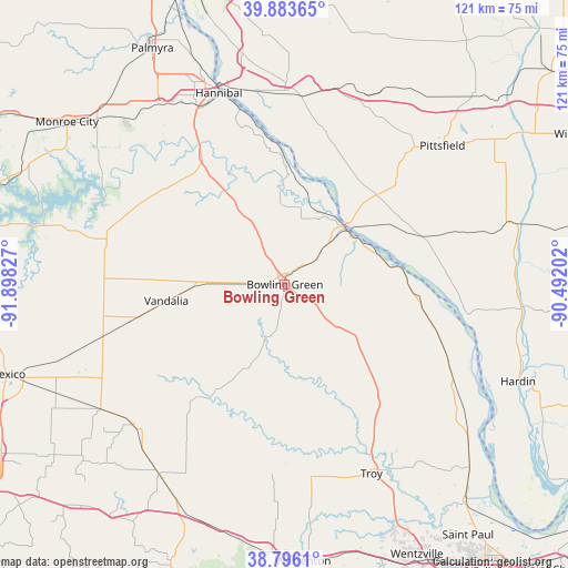
Bowling Green GPS coordinates[2]
39° 20' 31.164" North, 91° 11' 42.504" West
| Map corner | latitude | longitude |
|---|---|---|
| Upper-left | 39.88365°, | -91.89827° |
| Center: | 39.34199°, | -91.19514° |
| Lower-right: | 38.7961°, | -90.49202° |
| Map W x H: | 120.9×120.9 km | = 75.1×75.1mi |
| max Lat: | 71.29058° ⇑52% North |
| Bowling Green: | 39.34199° |
| min Lat: | ⇓48% South 19.06759° |
| min Long | Bowling Green | max Long |
| -171.73463° | -91.19514° | -66.98998° |
| W 37.5%⇐ | ⇒62.5% E |
Elevation
Elevation of Bowling Green is 274 m = 899 ft, and this is 20.8 m = 68 ft below average elevation for this country.
| Max E: |
3189 m = 10463 ft | 32.4% |
| Avg. | 294.8 m = 967 ft | |
| Bowling Green | 274 m = 899 ft | |
Min E: |
-60 m = -197 ft | 67.6% |
See also: United States elevation on elevation.city.
Geographical zone
Bowling Green is located in North temperate zone (between Tropic of Cancer and the Arctic Circle). Distance of this Northern Tropic circle is 1768.5 km =1098.9 mi to South.| Distance of | km | miles | from Bowling Green |
|---|---|---|---|
| North Pole | 5632.6 | 3499.9 | to North |
| Arctic Circle | 3026.8 | 1880.8 | to North |
| Tropic Cancer | 1768.5 | 1098.9 | to South |
| Equator | 4374.4 | 2718.1 | to South |


Nearby cities:
15 places around Bowling Green: (largest is in red/bold)
• Barry
41.4 km =25.7 mi,  18°
18°
• Center
34.1 km =21.2 mi,  302°
302°
• Elsberry
40.6 km =25.2 mi,  118°
118°
• Eolia
20 km =12.4 mi,  126°
126°
• Hannibal
43.1 km =26.8 mi,  341°
341°
• Hawk Point
41.6 km =25.8 mi,  172°
172°
• Laddonia
40.3 km =25 mi,  254°
254°
• Louisiana
17.1 km =10.6 mi,  46°
46°
• New London
32.3 km =20.1 mi,  326°
326°
• Perry
42.4 km =26.3 mi,  283°
283°
• Pittsfield
44.7 km =27.8 mi, 48°
• Pleasant Hill
29.9 km =18.6 mi,  67°
67°
• Troy
44.3 km =27.5 mi,  155°
155°
• Vandalia
25.5 km =15.8 mi,  262°
262°
• Wellsville
44.1 km =27.4 mi,  227°
227°
Sources, notices
• [Note1] Compared only with cities in United States existing in our database
• [Src1] Map data: © OpenStreetMap contributors (CC-BY-SA)
• [Src2] Other city data from geonames.org with taken over terms of usage.
• [Src3] Geographical zone / Annual Mean Temperature by Robert A. Rohde @ Wikipedia
