Palmyra geodata
Palmyra (Missouri) is a seat of a second-order administrative division; located in United States in America/Chicago (GMT-5) time zone. With population of 3,616 people, there are 8702 cities with bigger population in this country. Compared to other cities in United States, 51.4% of cities are located further ↓South; 63.1% of cities are located further →East and 50.7% of cities have lower elevation than Palmyra. Note1


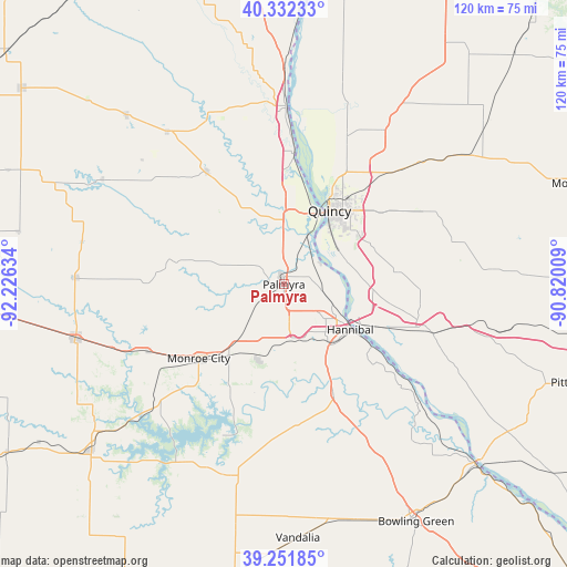
Palmyra GPS coordinates[2]
39° 47' 39.156" North, 91° 31' 23.556" West
| Map corner | latitude | longitude |
|---|---|---|
| Upper-left | 40.33233°, | -92.22634° |
| Center: | 39.79421°, | -91.52321° |
| Lower-right: | 39.25185°, | -90.82009° |
| Map W x H: | 120.1×120.1 km | = 74.6×74.6mi |
| max Lat: | 71.29058° ⇑48.6% North |
| Palmyra: | 39.79421° |
| min Lat: | ⇓51.4% South 19.06759° |
| min Long | Palmyra | max Long |
| -171.73463° | -91.52321° | -66.98998° |
| W 36.9%⇐ | ⇒63.1% E |
Elevation
Elevation of Palmyra is 201 m = 659 ft, and this is 93.8 m = 308 ft below average elevation for this country.
| Max E: |
3189 m = 10463 ft | 49.3% |
| Avg. | 294.8 m = 967 ft | |
| Palmyra | 201 m = 659 ft | |
Min E: |
-60 m = -197 ft | 50.7% |
See also: United States elevation on elevation.city.
Geographical zone
Palmyra is located in North temperate zone (between Tropic of Cancer and the Arctic Circle). Distance of this Northern Tropic circle is 1818.8 km =1130.1 mi to South.| Distance of | km | miles | from Palmyra |
|---|---|---|---|
| North Pole | 5582.4 | 3468.7 | to North |
| Arctic Circle | 2976.5 | 1849.5 | to North |
| Tropic Cancer | 1818.8 | 1130.1 | to South |
| Equator | 4424.7 | 2749.4 | to South |


Nearby cities:
15 places around Palmyra: (largest is in red/bold)
• Barry
42.9 km =26.7 mi,  105°
105°
• Canton
37.8 km =23.5 mi,  346°
346°
• Center
31.8 km =19.8 mi,  180°
180°
• Hannibal
17 km =10.6 mi,  124°
124°
• La Grange
27.7 km =17.2 mi,  4°
4°
• Lewistown
40.8 km =25.4 mi,  322°
322°
• Liberty
36.7 km =22.8 mi,  75°
75°
• Mendon
38.6 km =24 mi,  31°
31°
• Monroe City
23.9 km =14.9 mi,  229°
229°
• Monticello
39.5 km =24.5 mi,  335°
335°
• New London
25.5 km =15.8 mi,  155°
155°
• Payson
24.1 km =15 mi, 83°
• Perry
42.4 km =26.3 mi,  197°
197°
• Quincy
18.5 km =11.5 mi, 31°
• Ursa
33.9 km =21.1 mi,  23°
23°
Sources, notices
• [Note1] Compared only with cities in United States existing in our database
• [Src1] Map data: © OpenStreetMap contributors (CC-BY-SA)
• [Src2] Other city data from geonames.org with taken over terms of usage.
• [Src3] Geographical zone / Annual Mean Temperature by Robert A. Rohde @ Wikipedia
