Wickliffe geodata
Wickliffe (Kentucky) is a seat of a second-order administrative division; located in United States in America/Chicago (GMT-5) time zone. With population of 685 people, there are 18830 cities with bigger population in this country. Compared to other cities in United States, 66.3% of cities are located further ↑North; 56.4% of cities are located further →East and 68.8% of cities have higher elevation than Wickliffe. Note1


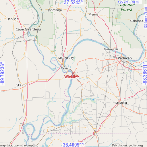
Wickliffe GPS coordinates[2]
36° 57' 53.208" North, 89° 5' 21.228" West
| Map corner | latitude | longitude |
|---|---|---|
| Upper-left | 37.5245°, | -89.79236° |
| Center: | 36.96478°, | -89.08923° |
| Lower-right: | 36.40091°, | -88.38611° |
| Map W x H: | 124.9×124.9 km | = 77.6×77.6mi |
| max Lat: | 71.29058° ⇑66.3% North |
| Wickliffe: | 36.96478° |
| min Lat: | ⇓33.7% South 19.06759° |
| min Long | Wickliffe | max Long |
| -171.73463° | -89.08923° | -66.98998° |
| W 43.6%⇐ | ⇒56.4% E |
Elevation
Elevation of Wickliffe is 108 m = 354 ft, and this is 186.8 m = 613 ft below average elevation for this country.
| Max E: |
3189 m = 10463 ft | 68.8% |
| Avg. | 294.8 m = 967 ft | |
| Wickliffe | 108 m = 354 ft | |
Min E: |
-60 m = -197 ft | 31.2% |
See also: United States elevation on elevation.city.
Geographical zone
Wickliffe is located in North temperate zone (between Tropic of Cancer and the Arctic Circle). Distance of this Northern Tropic circle is 1504.2 km =934.7 mi to South.| Distance of | km | miles | from Wickliffe |
|---|---|---|---|
| North Pole | 5897 | 3664.2 | to North |
| Arctic Circle | 3291.1 | 2045 | to North |
| Tropic Cancer | 1504.2 | 934.7 | to South |
| Equator | 4110.1 | 2553.9 | to South |


Nearby cities:
15 places around Wickliffe: (largest is in red/bold)
• Bardwell
12.6 km =7.8 mi,  146°
146°
• Barlow
10.4 km =6.5 mi,  21°
21°
• Bertrand
32.9 km =20.4 mi,  259°
259°
• Cairo
9 km =5.6 mi,  300°
300°
• Charleston
23.7 km =14.7 mi, 258°
• Clinton
34.2 km =21.3 mi,  165°
165°
• East Prairie
33.4 km =20.8 mi,  232°
232°
• Kevil
22.4 km =13.9 mi,  53°
53°
• La Center
16.1 km =10 mi,  39°
39°
• Massac
32.4 km =20.1 mi,  79°
79°
• Metropolis
37.9 km =23.5 mi,  56°
56°
• Mound City
14.9 km =9.3 mi,  334°
334°
• Mounds
19.2 km =11.9 mi, 329°
• Olive Branch
32.5 km =20.2 mi,  314°
314°
• Tamms
34.1 km =21.2 mi, 331°
Sources, notices
• [Note1] Compared only with cities in United States existing in our database
• [Src1] Map data: © OpenStreetMap contributors (CC-BY-SA)
• [Src2] Other city data from geonames.org with taken over terms of usage.
• [Src3] Geographical zone / Annual Mean Temperature by Robert A. Rohde @ Wikipedia
