East Prairie geodata
East Prairie (Missouri) is a populated place; located in United States in America/Chicago (GMT-5) time zone. With population of 3,155 people, there are 9366 cities with bigger population in this country. Compared to other cities in United States, 67% of cities are located further ↑North; 57.3% of cities are located further →East and 71.1% of cities have higher elevation than East Prairie. Note1
Administrative division(s):
- Level 1: Missouri
- Level 2: Mississippi County
- Level 3: Township of Saint James


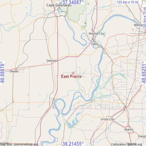
East Prairie GPS coordinates[2]
36° 46' 47.208" North, 89° 23' 8.268" West
| Map corner | latitude | longitude |
|---|---|---|
| Upper-left | 37.34087°, | -90.08876° |
| Center: | 36.77978°, | -89.38563° |
| Lower-right: | 36.21455°, | -88.68251° |
| Map W x H: | 125.2×125.2 km | = 77.8×77.8mi |
| max Lat: | 71.29058° ⇑67% North |
| East Prairie: | 36.77978° |
| min Lat: | ⇓33% South 19.06759° |
| min Long | East Prairie | max Long |
| -171.73463° | -89.38563° | -66.98998° |
| W 42.7%⇐ | ⇒57.3% E |
Elevation
Elevation of East Prairie is 94 m = 308 ft, and this is 200.8 m = 659 ft below average elevation for this country.
| Max E: |
3189 m = 10463 ft | 71.1% |
| Avg. | 294.8 m = 967 ft | |
| East Prairie | 94 m = 308 ft | |
Min E: |
-60 m = -197 ft | 28.9% |
See also: United States elevation on elevation.city.
Geographical zone
East Prairie is located in North temperate zone (between Tropic of Cancer and the Arctic Circle). Distance of this Northern Tropic circle is 1483.6 km =921.9 mi to South.| Distance of | km | miles | from East Prairie |
|---|---|---|---|
| North Pole | 5917.5 | 3677 | to North |
| Arctic Circle | 3311.6 | 2057.7 | to North |
| Tropic Cancer | 1483.6 | 921.9 | to South |
| Equator | 4089.5 | 2541.1 | to South |


Nearby cities:
15 places around East Prairie: (largest is in red/bold)
• Bardwell
34.9 km =21.7 mi,  73°
73°
• Benton
38.7 km =24 mi,  336°
336°
• Bertrand
15.6 km =9.7 mi, 337°
• Cairo
31.2 km =19.4 mi,  36°
36°
• Charleston
16 km =9.9 mi,  11°
11°
• Clinton
37.1 km =23.1 mi,  109°
109°
• Hickman
29.2 km =18.1 mi,  142°
142°
• Lilbourn
29.2 km =18.1 mi,  224°
224°
• Matthews
18.1 km =11.2 mi,  262°
262°
• Miner
18.4 km =11.4 mi,  312°
312°
• Morehouse
27.7 km =17.2 mi,  285°
285°
• Morley
35.5 km =22.1 mi,  325°
325°
• New Madrid
25 km =15.5 mi,  210°
210°
• Sikeston
21 km =13 mi,  300°
300°
• Wickliffe
33.4 km =20.8 mi,  52°
52°
Sources, notices
• [Note1] Compared only with cities in United States existing in our database
• [Src1] Map data: © OpenStreetMap contributors (CC-BY-SA)
• [Src2] Other city data from geonames.org with taken over terms of usage.
• [Src3] Geographical zone / Annual Mean Temperature by Robert A. Rohde @ Wikipedia
