Chesterfield geodata
Chesterfield (Missouri) is a populated place; located in United States in America/Chicago (GMT-5) time zone. With population of 47,864 people, there are 1003 cities with bigger population in this country. Compared to other cities in United States, 57.7% of cities are located further ↑North; 61.1% of cities are located further →East and 62.7% of cities have higher elevation than Chesterfield. Note1
Administrative division(s):
- Level 1: Missouri
- Level 2: Saint Louis County
- Level 3: Township of Chesterfield


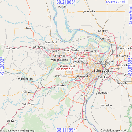
Chesterfield GPS coordinates[2]
38° 39' 47.196" North, 90° 34' 37.452" West
| Map corner | latitude | longitude |
|---|---|---|
| Upper-left | 39.21003°, | -91.2802° |
| Center: | 38.66311°, | -90.57707° |
| Lower-right: | 38.11199°, | -89.87395° |
| Map W x H: | 122.1×122.1 km | = 75.9×75.9mi |
| max Lat: | 71.29058° ⇑57.7% North |
| Chesterfield: | 38.66311° |
| min Lat: | ⇓42.3% South 19.06759° |
| min Long | Chesterfield | max Long |
| -171.73463° | -90.57707° | -66.98998° |
| W 38.9%⇐ | ⇒61.1% E |
Elevation
Elevation of Chesterfield is 140 m = 459 ft, and this is 154.8 m = 508 ft below average elevation for this country.
| Max E: |
3189 m = 10463 ft | 62.7% |
| Avg. | 294.8 m = 967 ft | |
| Chesterfield | 140 m = 459 ft | |
Min E: |
-60 m = -197 ft | 37.3% |
See also: Chesterfield elevation on elevation.city.
Geographical zone
Chesterfield is located in North temperate zone (between Tropic of Cancer and the Arctic Circle). Distance of this Northern Tropic circle is 1693 km =1052 mi to South.| Distance of | km | miles | from Chesterfield |
|---|---|---|---|
| North Pole | 5708.1 | 3546.8 | to North |
| Arctic Circle | 3102.2 | 1927.6 | to North |
| Tropic Cancer | 1693 | 1052 | to South |
| Equator | 4298.9 | 2671.2 | to South |


Nearby cities:
15 places around Chesterfield: (largest is in red/bold)
• Ballwin
8 km =5 mi,  160°
160°
• Clarkson Valley
5.1 km =3.2 mi,  192°
192°
• Cottleville
11.4 km =7.1 mi,  324°
324°
• Creve Coeur
13.4 km =8.3 mi,  91°
91°
• Des Peres
14.3 km =8.9 mi,  118°
118°
• Ellisville
7.9 km =4.9 mi, 186°
• Frontenac
14.4 km =8.9 mi,  102°
102°
• Manchester
9.4 km =5.8 mi,  141°
141°
• Maryland Heights
13.9 km =8.6 mi,  66°
66°
• Saint Charles
15.8 km =9.8 mi,  31°
31°
• Town and Country
11.4 km =7.1 mi, 119°
• Valley Park
14.6 km =9.1 mi,  149°
149°
• Weldon Spring
11.2 km =7 mi,  299°
299°
• Wildwood
11.6 km =7.2 mi,  219°
219°
• Winchester
9.2 km =5.7 mi, 152°
Sources, notices
• [Note1] Compared only with cities in United States existing in our database
• [Src1] Map data: © OpenStreetMap contributors (CC-BY-SA)
• [Src2] Other city data from geonames.org with taken over terms of usage.
• [Src3] Geographical zone / Annual Mean Temperature by Robert A. Rohde @ Wikipedia
