Crane geodata
Crane (Missouri) is a populated place; located in United States in America/Chicago (GMT-5) time zone. With population of 1,352 people, there are 14337 cities with bigger population in this country. Compared to other cities in United States, 66.6% of cities are located further ↑North; 67.7% of cities are located further →East and 79.8% of cities have lower elevation than Crane. Note1


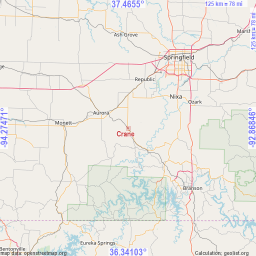
Crane GPS coordinates[2]
36° 54' 19.224" North, 93° 34' 17.688" West
| Map corner | latitude | longitude |
|---|---|---|
| Upper-left | 37.4655°, | -94.27471° |
| Center: | 36.90534°, | -93.57158° |
| Lower-right: | 36.34103°, | -92.86846° |
| Map W x H: | 125×125 km | = 77.7×77.7mi |
| max Lat: | 71.29058° ⇑66.6% North |
| Crane: | 36.90534° |
| min Lat: | ⇓33.4% South 19.06759° |
| min Long | Crane | max Long |
| -171.73463° | -93.57158° | -66.98998° |
| W 32.3%⇐ | ⇒67.7% E |
Elevation
Elevation of Crane is 351 m = 1152 ft, and this is 56.2 m = 184 ft above average elevation for this country.
| Max E: |
3189 m = 10463 ft | 20.2% |
| Crane | 351 m 1152 ft | |
| Avg. | 294.8 m = 967 ft | |
Min E: |
-60 m = -197 ft | 79.8% |
See also: United States elevation on elevation.city.
Geographical zone
Crane is located in North temperate zone (between Tropic of Cancer and the Arctic Circle). Distance of this Northern Tropic circle is 1497.6 km =930.6 mi to South.| Distance of | km | miles | from Crane |
|---|---|---|---|
| North Pole | 5903.6 | 3668.3 | to North |
| Arctic Circle | 3297.7 | 2049.1 | to North |
| Tropic Cancer | 1497.6 | 930.6 | to South |
| Equator | 4103.5 | 2549.8 | to South |


Nearby cities:
15 places around Crane: (largest is in red/bold)
• Aurora
14.9 km =9.3 mi,  299°
299°
• Battlefield
29.4 km =18.3 mi,  37°
37°
• Billings
18.1 km =11.2 mi,  5°
5°
• Clever
16.4 km =10.2 mi,  32°
32°
• Galena
14.5 km =9 mi,  139°
139°
• Highlandville
26.1 km =16.2 mi,  83°
83°
• Marionville
12.3 km =7.6 mi,  331°
331°
• Monett
31.8 km =19.8 mi,  274°
274°
• Mount Vernon
31.1 km =19.3 mi,  315°
315°
• Nixa
29 km =18 mi,  58°
58°
• Purdy
32.6 km =20.3 mi,  252°
252°
• Reeds Spring
24.4 km =15.2 mi, 135°
• Republic
25.2 km =15.7 mi,  18°
18°
• Shell Knob
30.9 km =19.2 mi,  190°
190°
• Verona
21 km =13 mi,  288°
288°
Sources, notices
• [Note1] Compared only with cities in United States existing in our database
• [Src1] Map data: © OpenStreetMap contributors (CC-BY-SA)
• [Src2] Other city data from geonames.org with taken over terms of usage.
• [Src3] Geographical zone / Annual Mean Temperature by Robert A. Rohde @ Wikipedia
