Clever geodata
Clever (Missouri) is a populated place; located in United States in America/Chicago (GMT-5) time zone. With population of 2,517 people, there are 10576 cities with bigger population in this country. Compared to other cities in United States, 66% of cities are located further ↑North; 67.4% of cities are located further →East and 85.3% of cities have lower elevation than Clever. Note1
Administrative division(s):
- Level 1: Missouri
- Level 2: Christian County
- Level 3: Township of Lincoln


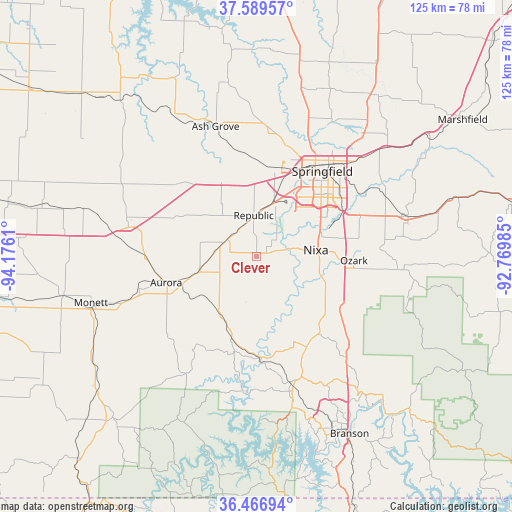
Clever GPS coordinates[2]
37° 1' 49.188" North, 93° 28' 22.692" West
| Map corner | latitude | longitude |
|---|---|---|
| Upper-left | 37.58957°, | -94.1761° |
| Center: | 37.03033°, | -93.47297° |
| Lower-right: | 36.46694°, | -92.76985° |
| Map W x H: | 124.8×124.8 km | = 77.5×77.5mi |
| max Lat: | 71.29058° ⇑66% North |
| Clever: | 37.03033° |
| min Lat: | ⇓34% South 19.06759° |
| min Long | Clever | max Long |
| -171.73463° | -93.47297° | -66.98998° |
| W 32.6%⇐ | ⇒67.4% E |
Elevation
Elevation of Clever is 430 m = 1411 ft, and this is 135.2 m = 444 ft above average elevation for this country.
| Max E: |
3189 m = 10463 ft | 14.7% |
| Clever | 430 m 1411 ft | |
| Avg. | 294.8 m = 967 ft | |
Min E: |
-60 m = -197 ft | 85.3% |
See also: United States elevation on elevation.city.
Geographical zone
Clever is located in North temperate zone (between Tropic of Cancer and the Arctic Circle). Distance of this Northern Tropic circle is 1511.5 km =939.2 mi to South.| Distance of | km | miles | from Clever |
|---|---|---|---|
| North Pole | 5889.7 | 3659.7 | to North |
| Arctic Circle | 3283.8 | 2040.5 | to North |
| Tropic Cancer | 1511.5 | 939.2 | to South |
| Equator | 4117.4 | 2558.4 | to South |


Nearby cities:
15 places around Clever: (largest is in red/bold)
• Aurora
22.7 km =14.1 mi,  253°
253°
• Battlefield
13.2 km =8.2 mi,  43°
43°
• Billings
8.2 km =5.1 mi,  300°
300°
• Crane
16.4 km =10.2 mi,  212°
212°
• Fremont Hills
20.3 km =12.6 mi,  79°
79°
• Galena
25 km =15.5 mi,  178°
178°
• Highlandville
20.2 km =12.6 mi,  122°
122°
• Marionville
14.9 km =9.3 mi,  258°
258°
• Mount Vernon
31.7 km =19.7 mi,  284°
284°
• Nixa
15.9 km =9.9 mi, 84°
• Ozark
23.7 km =14.7 mi,  92°
92°
• Republic
10 km =6.2 mi,  356°
356°
• Springfield
25.8 km =16 mi, 36°
• Verona
29.6 km =18.4 mi, 255°
• Willard
30.8 km =19.1 mi,  7°
7°
Sources, notices
• [Note1] Compared only with cities in United States existing in our database
• [Src1] Map data: © OpenStreetMap contributors (CC-BY-SA)
• [Src2] Other city data from geonames.org with taken over terms of usage.
• [Src3] Geographical zone / Annual Mean Temperature by Robert A. Rohde @ Wikipedia
