Fredericktown geodata
Fredericktown (Missouri) is a seat of a second-order administrative division; located in United States in America/Chicago (GMT-5) time zone. With population of 4,076 people, there are 8129 cities with bigger population in this country. Compared to other cities in United States, 63.8% of cities are located further ↑North; 60% of cities are located further →East and 57.2% of cities have lower elevation than Fredericktown. Note1
Administrative division(s):
- Level 1: Missouri
- Level 2: Madison County
- Level 3: Township of Saint Michael


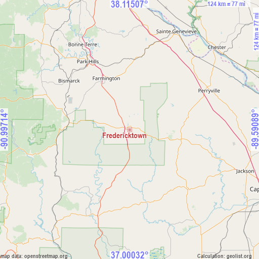
Fredericktown GPS coordinates[2]
37° 33' 35.208" North, 90° 17' 38.436" West
| Map corner | latitude | longitude |
|---|---|---|
| Upper-left | 38.11507°, | -90.99714° |
| Center: | 37.55978°, | -90.29401° |
| Lower-right: | 37.00032°, | -89.59089° |
| Map W x H: | 123.9×123.9 km | = 77×77mi |
| max Lat: | 71.29058° ⇑63.8% North |
| Fredericktown: | 37.55978° |
| min Lat: | ⇓36.2% South 19.06759° |
| min Long | Fredericktown | max Long |
| -171.73463° | -90.29401° | -66.98998° |
| W 40%⇐ | ⇒60% E |
Elevation
Elevation of Fredericktown is 227 m = 745 ft, and this is 67.8 m = 222 ft below average elevation for this country.
| Max E: |
3189 m = 10463 ft | 42.8% |
| Avg. | 294.8 m = 967 ft | |
| Fredericktown | 227 m = 745 ft | |
Min E: |
-60 m = -197 ft | 57.2% |
See also: United States elevation on elevation.city.
Geographical zone
Fredericktown is located in North temperate zone (between Tropic of Cancer and the Arctic Circle). Distance of this Northern Tropic circle is 1570.3 km =975.7 mi to South.| Distance of | km | miles | from Fredericktown |
|---|---|---|---|
| North Pole | 5830.8 | 3623.1 | to North |
| Arctic Circle | 3224.9 | 2003.9 | to North |
| Tropic Cancer | 1570.3 | 975.7 | to South |
| Equator | 4176.3 | 2595 | to South |


Nearby cities:
15 places around Fredericktown: (largest is in red/bold)
• Arcadia
29.7 km =18.5 mi,  276°
276°
• Bismarck
37.3 km =23.2 mi,  308°
308°
• Desloge
40.2 km =25 mi,  329°
329°
• Doe Run
27.1 km =16.8 mi,  318°
318°
• Elvins
37.3 km =23.2 mi, 325°
• Esther
37 km =23 mi, 330°
• Farmington
27 km =16.8 mi,  335°
335°
• Flat River
37.8 km =23.5 mi, 328°
• Iron Mountain Lake
32.5 km =20.2 mi,  297°
297°
• Ironton
29.7 km =18.5 mi, 278°
• Leadwood
43.1 km =26.8 mi, 322°
• Marble Hill
40.2 km =25 mi,  134°
134°
• Park Hills
38.2 km =23.7 mi, 328°
• Perryville
42.3 km =26.3 mi,  64°
64°
• Pilot Knob
31.3 km =19.4 mi, 282°
Sources, notices
• [Note1] Compared only with cities in United States existing in our database
• [Src1] Map data: © OpenStreetMap contributors (CC-BY-SA)
• [Src2] Other city data from geonames.org with taken over terms of usage.
• [Src3] Geographical zone / Annual Mean Temperature by Robert A. Rohde @ Wikipedia
