Perryville geodata
Perryville (Missouri) is a seat of a second-order administrative division; located in United States in America/Chicago (GMT-5) time zone. With population of 8,398 people, there are 5078 cities with bigger population in this country. Compared to other cities in United States, 63.1% of cities are located further ↑North; 58.6% of cities are located further →East and 55.7% of cities have higher elevation than Perryville. Note1


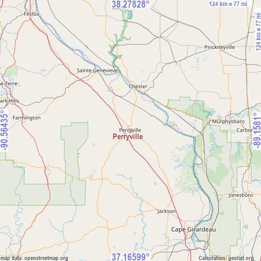
Perryville GPS coordinates[2]
37° 43' 27.192" North, 89° 51' 40.392" West
| Map corner | latitude | longitude |
|---|---|---|
| Upper-left | 38.27828°, | -90.56435° |
| Center: | 37.72422°, | -89.86122° |
| Lower-right: | 37.16599°, | -89.1581° |
| Map W x H: | 123.7×123.7 km | = 76.9×76.9mi |
| max Lat: | 71.29058° ⇑63.1% North |
| Perryville: | 37.72422° |
| min Lat: | ⇓36.9% South 19.06759° |
| min Long | Perryville | max Long |
| -171.73463° | -89.86122° | -66.98998° |
| W 41.4%⇐ | ⇒58.6% E |
Elevation
Elevation of Perryville is 177 m = 581 ft, and this is 117.8 m = 386 ft below average elevation for this country.
| Max E: |
3189 m = 10463 ft | 55.7% |
| Avg. | 294.8 m = 967 ft | |
| Perryville | 177 m = 581 ft | |
Min E: |
-60 m = -197 ft | 44.3% |
See also: United States elevation on elevation.city.
Geographical zone
Perryville is located in North temperate zone (between Tropic of Cancer and the Arctic Circle). Distance of this Northern Tropic circle is 1588.6 km =987.1 mi to South.| Distance of | km | miles | from Perryville |
|---|---|---|---|
| North Pole | 5812.5 | 3611.7 | to North |
| Arctic Circle | 3206.6 | 1992.5 | to North |
| Tropic Cancer | 1588.6 | 987.1 | to South |
| Equator | 4194.5 | 2606.3 | to South |


Nearby cities:
15 places around Perryville: (largest is in red/bold)
• Ava
37 km =23 mi,  60°
60°
• Bloomsdale
44.6 km =27.7 mi,  315°
315°
• Chester
21.3 km =13.2 mi,  9°
9°
• Evansville
41.3 km =25.7 mi,  350°
350°
• Fredericktown
42.3 km =26.3 mi,  244°
244°
• Grand Tower
33.8 km =21 mi,  108°
108°
• Harrison
46.8 km =29.1 mi,  80°
80°
• Jackson
41.7 km =25.9 mi,  155°
155°
• Murphysboro
46.5 km =28.9 mi, 84°
• Percy
38.8 km =24.1 mi,  33°
33°
• Prairie du Rocher
44.9 km =27.9 mi,  332°
332°
• Sainte Genevieve
32.7 km =20.3 mi, 331°
• Sparta
46.5 km =28.9 mi,  17°
17°
• Steeleville
36.2 km =22.5 mi, 29°
• Willisville
37.5 km =23.3 mi,  39°
39°
Sources, notices
• [Note1] Compared only with cities in United States existing in our database
• [Src1] Map data: © OpenStreetMap contributors (CC-BY-SA)
• [Src2] Other city data from geonames.org with taken over terms of usage.
• [Src3] Geographical zone / Annual Mean Temperature by Robert A. Rohde @ Wikipedia
