Horine geodata
Horine (Missouri) is a populated place; located in United States in America/Chicago (GMT-5) time zone. With population of 821 people, there are 17610 cities with bigger population in this country. Compared to other cities in United States, 60.2% of cities are located further ↑North; 60.6% of cities are located further →East and 64.7% of cities have higher elevation than Horine. Note1
Administrative division(s):
- Level 1: Missouri
- Level 2: Jefferson County
- Level 3: Township of Joachim


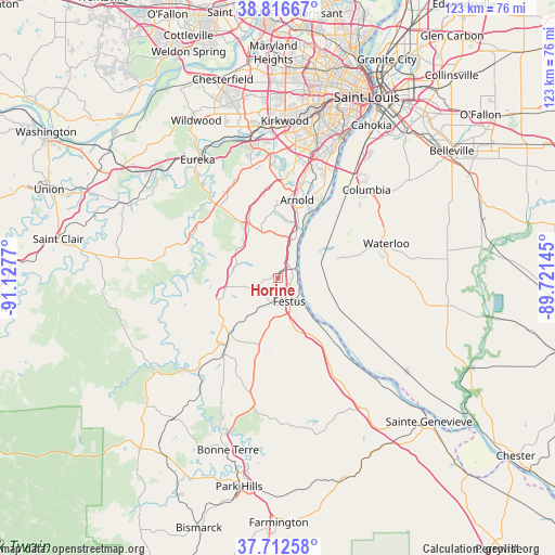
Horine GPS coordinates[2]
38° 16' 0.192" North, 90° 25' 28.452" West
| Map corner | latitude | longitude |
|---|---|---|
| Upper-left | 38.81667°, | -91.1277° |
| Center: | 38.26672°, | -90.42457° |
| Lower-right: | 37.71258°, | -89.72145° |
| Map W x H: | 122.8×122.8 km | = 76.3×76.3mi |
| max Lat: | 71.29058° ⇑60.2% North |
| Horine: | 38.26672° |
| min Lat: | ⇓39.8% South 19.06759° |
| min Long | Horine | max Long |
| -171.73463° | -90.42457° | -66.98998° |
| W 39.4%⇐ | ⇒60.6% E |
Elevation
Elevation of Horine is 130 m = 427 ft, and this is 164.8 m = 541 ft below average elevation for this country.
| Max E: |
3189 m = 10463 ft | 64.7% |
| Avg. | 294.8 m = 967 ft | |
| Horine | 130 m = 427 ft | |
Min E: |
-60 m = -197 ft | 35.3% |
See also: United States elevation on elevation.city.
Geographical zone
Horine is located in North temperate zone (between Tropic of Cancer and the Arctic Circle). Distance of this Northern Tropic circle is 1648.9 km =1024.6 mi to South.| Distance of | km | miles | from Horine |
|---|---|---|---|
| North Pole | 5752.2 | 3574.3 | to North |
| Arctic Circle | 3146.3 | 1955 | to North |
| Tropic Cancer | 1648.9 | 1024.6 | to South |
| Equator | 4254.9 | 2643.9 | to South |


Nearby cities:
15 places around Horine: (largest is in red/bold)
• Arnold
18.9 km =11.7 mi,  12°
12°
• Barnhart
9 km =5.6 mi,  17°
17°
• Byrnes Mill
23.5 km =14.6 mi,  324°
324°
• Cedar Hill
21.2 km =13.2 mi,  297°
297°
• Crystal City
6.4 km =4 mi,  141°
141°
• De Soto
18.2 km =11.3 mi,  218°
218°
• Festus
5.7 km =3.5 mi,  154°
154°
• Herculaneum
3.9 km =2.4 mi,  87°
87°
• High Ridge
23.5 km =14.6 mi,  335°
335°
• Hillsboro
12.7 km =7.9 mi,  252°
252°
• Imperial
12.1 km =7.5 mi, 19°
• Olympian Village
14.8 km =9.2 mi,  191°
191°
• Pevely
3.2 km =2 mi,  54°
54°
• Riverside
4.5 km =2.8 mi,  60°
60°
• Valmeyer
13.6 km =8.5 mi,  71°
71°
Sources, notices
• [Note1] Compared only with cities in United States existing in our database
• [Src1] Map data: © OpenStreetMap contributors (CC-BY-SA)
• [Src2] Other city data from geonames.org with taken over terms of usage.
• [Src3] Geographical zone / Annual Mean Temperature by Robert A. Rohde @ Wikipedia
