Licking geodata
Licking (Missouri) is a populated place; located in United States in America/Chicago (GMT-5) time zone. With population of 3,115 people, there are 9436 cities with bigger population in this country. Compared to other cities in United States, 64.1% of cities are located further ↑North; 63.8% of cities are located further →East and 82.9% of cities have lower elevation than Licking. Note1


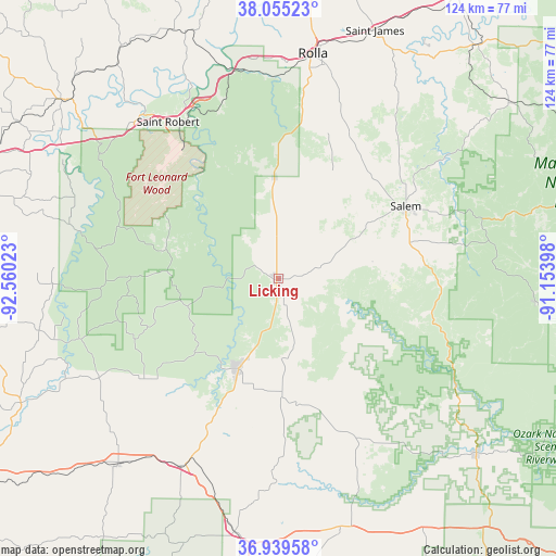
Licking GPS coordinates[2]
37° 29' 58.164" North, 91° 51' 25.56" West
| Map corner | latitude | longitude |
|---|---|---|
| Upper-left | 38.05523°, | -92.56023° |
| Center: | 37.49949°, | -91.8571° |
| Lower-right: | 36.93958°, | -91.15398° |
| Map W x H: | 124×124 km | = 77.1×77.1mi |
| max Lat: | 71.29058° ⇑64.1% North |
| Licking: | 37.49949° |
| min Lat: | ⇓35.9% South 19.06759° |
| min Long | Licking | max Long |
| -171.73463° | -91.8571° | -66.98998° |
| W 36.2%⇐ | ⇒63.8% E |
Elevation
Elevation of Licking is 388 m = 1273 ft, and this is 93.2 m = 306 ft above average elevation for this country.
| Max E: |
3189 m = 10463 ft | 17.1% |
| Licking | 388 m 1273 ft | |
| Avg. | 294.8 m = 967 ft | |
Min E: |
-60 m = -197 ft | 82.9% |
See also: United States elevation on elevation.city.
Geographical zone
Licking is located in North temperate zone (between Tropic of Cancer and the Arctic Circle). Distance of this Northern Tropic circle is 1563.6 km =971.6 mi to South.| Distance of | km | miles | from Licking |
|---|---|---|---|
| North Pole | 5837.5 | 3627.3 | to North |
| Arctic Circle | 3231.6 | 2008 | to North |
| Tropic Cancer | 1563.6 | 971.6 | to South |
| Equator | 4169.6 | 2590.9 | to South |


Nearby cities:
15 places around Licking: (largest is in red/bold)
• Cabool
47 km =29.2 mi,  207°
207°
• Crocker
61.5 km =38.2 mi,  324°
324°
• Dixon
58.6 km =36.4 mi,  339°
339°
• Doolittle
49.1 km =30.5 mi,  357°
357°
• Eminence
58.8 km =36.5 mi,  131°
131°
• Fort Leonard Wood
35 km =21.7 mi,  310°
310°
• Houston
21.2 km =13.2 mi,  204°
204°
• Mountain Grove
54.5 km =33.9 mi,  221°
221°
• Mountain View
57.7 km =35.9 mi,  166°
166°
• Rolla
50.8 km =31.6 mi,  8°
8°
• Saint James
59.3 km =36.8 mi,  21°
21°
• Saint Robert
46.2 km =28.7 mi, 322°
• Salem
32.6 km =20.3 mi,  60°
60°
• Waynesville
47.5 km =29.5 mi, 320°
• Willow Springs
57.3 km =35.6 mi,  190°
190°
Sources, notices
• [Note1] Compared only with cities in United States existing in our database
• [Src1] Map data: © OpenStreetMap contributors (CC-BY-SA)
• [Src2] Other city data from geonames.org with taken over terms of usage.
• [Src3] Geographical zone / Annual Mean Temperature by Robert A. Rohde @ Wikipedia
