Odessa geodata
Odessa (Missouri) is a populated place; located in United States in America/Chicago (GMT-5) time zone. With population of 5,178 people, there are 7024 cities with bigger population in this country. Compared to other cities in United States, 54.9% of cities are located further ↑North; 68.5% of cities are located further →East and 70.4% of cities have lower elevation than Odessa. Note1
Administrative division(s):
- Level 1: Missouri
- Level 2: Lafayette County
- Level 3: Township of Sni-A-Bar


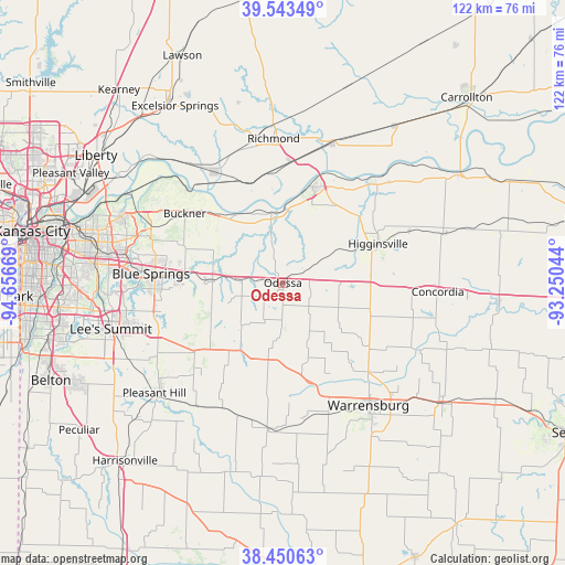
Odessa GPS coordinates[2]
38° 59' 57.012" North, 93° 57' 12.816" West
| Map corner | latitude | longitude |
|---|---|---|
| Upper-left | 39.54349°, | -94.65669° |
| Center: | 38.99917°, | -93.95356° |
| Lower-right: | 38.45063°, | -93.25044° |
| Map W x H: | 121.5×121.5 km | = 75.5×75.5mi |
| max Lat: | 71.29058° ⇑54.9% North |
| Odessa: | 38.99917° |
| min Lat: | ⇓45.1% South 19.06759° |
| min Long | Odessa | max Long |
| -171.73463° | -93.95356° | -66.98998° |
| W 31.5%⇐ | ⇒68.5% E |
Elevation
Elevation of Odessa is 288 m = 945 ft, and this is 6.8 m = 22 ft below average elevation for this country.
| Max E: |
3189 m = 10463 ft | 29.6% |
| Avg. | 294.8 m = 967 ft | |
| Odessa | 288 m = 945 ft | |
Min E: |
-60 m = -197 ft | 70.4% |
See also: United States elevation on elevation.city.
Geographical zone
Odessa is located in North temperate zone (between Tropic of Cancer and the Arctic Circle). Distance of this Northern Tropic circle is 1730.4 km =1075.2 mi to South.| Distance of | km | miles | from Odessa |
|---|---|---|---|
| North Pole | 5670.8 | 3523.7 | to North |
| Arctic Circle | 3064.9 | 1904.4 | to North |
| Tropic Cancer | 1730.4 | 1075.2 | to South |
| Equator | 4336.3 | 2694.5 | to South |


Nearby cities:
15 places around Odessa: (largest is in red/bold)
• Albany
28.5 km =17.7 mi,  331°
331°
• Blue Springs
28.4 km =17.6 mi,  273°
273°
• Buckner
25.8 km =16 mi,  305°
305°
• Grain Valley
21.2 km =13.2 mi, 274°
• Hardin
31.9 km =19.8 mi,  18°
18°
• Higginsville
22 km =13.7 mi,  68°
68°
• Holden
31.9 km =19.8 mi,  185°
185°
• Lake Lotawana
26.5 km =16.5 mi,  251°
251°
• Lake Tapawingo
31 km =19.3 mi, 274°
• Lexington
21.6 km =13.4 mi, 17°
• Lone Jack
23.8 km =14.8 mi,  233°
233°
• Oak Grove
15.2 km =9.4 mi, 272°
• Orrick
27.9 km =17.3 mi, 328°
• Richmond
31.1 km =19.3 mi,  356°
356°
• Wellington
15.2 km =9.4 mi,  350°
350°
Sources, notices
• [Note1] Compared only with cities in United States existing in our database
• [Src1] Map data: © OpenStreetMap contributors (CC-BY-SA)
• [Src2] Other city data from geonames.org with taken over terms of usage.
• [Src3] Geographical zone / Annual Mean Temperature by Robert A. Rohde @ Wikipedia
