Cleary geodata
Cleary (Mississippi) is a populated place; located in United States in America/Chicago (GMT-5) time zone. With population of 1,544 people, there are 13493 cities with bigger population in this country. Compared to other cities in United States, 88.2% of cities are located further ↑North; 59.6% of cities are located further →East and 66.2% of cities have higher elevation than Cleary. Note1


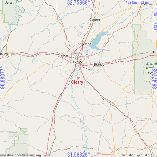
Cleary GPS coordinates[2]
32° 9' 55.548" North, 90° 10' 50.304" West
| Map corner | latitude | longitude |
|---|---|---|
| Upper-left | 32.75868°, | -90.88377° |
| Center: | 32.16543°, | -90.18064° |
| Lower-right: | 31.56829°, | -89.47752° |
| Map W x H: | 132.4×132.4 km | = 82.3×82.3mi |
| max Lat: | 71.29058° ⇑88.2% North |
| Cleary: | 32.16543° |
| min Lat: | ⇓11.8% South 19.06759° |
| min Long | Cleary | max Long |
| -171.73463° | -90.18064° | -66.98998° |
| W 40.4%⇐ | ⇒59.6% E |
Elevation
Elevation of Cleary is 122 m = 400 ft, and this is 172.8 m = 567 ft below average elevation for this country.
| Max E: |
3189 m = 10463 ft | 66.2% |
| Avg. | 294.8 m = 967 ft | |
| Cleary | 122 m = 400 ft | |
Min E: |
-60 m = -197 ft | 33.8% |
See also: United States elevation on elevation.city.
Geographical zone
Cleary is located in North temperate zone (between Tropic of Cancer and the Arctic Circle). Distance of this Northern Tropic circle is 970.5 km =603 mi to South.| Distance of | km | miles | from Cleary |
|---|---|---|---|
| North Pole | 6430.6 | 3995.8 | to North |
| Arctic Circle | 3824.7 | 2376.6 | to North |
| Tropic Cancer | 970.5 | 603 | to South |
| Equator | 3576.5 | 2222.3 | to South |


Nearby cities:
15 places around Cleary: (largest is in red/bold)
• Bolton
33.3 km =20.7 mi,  307°
307°
• Brandon
21.9 km =13.6 mi,  56°
56°
• Byram
6.3 km =3.9 mi,  284°
284°
• Clinton
23.7 km =14.7 mi,  325°
325°
• Crystal Springs
25.8 km =16 mi,  220°
220°
• Florence
4.8 km =3 mi,  105°
105°
• Flowood
16.5 km =10.3 mi,  13°
13°
• Jackson
14.8 km =9.2 mi,  358°
358°
• Madison
33.5 km =20.8 mi, 10°
• Mendenhall
37 km =23 mi,  127°
127°
• Pearl
13 km =8.1 mi,  20°
20°
• Raymond
25 km =15.5 mi,  294°
294°
• Richland
8.4 km =5.2 mi, 14°
• Ridgeland
29.6 km =18.4 mi, 8°
• Terry
13.2 km =8.2 mi,  234°
234°
Sources, notices
• [Note1] Compared only with cities in United States existing in our database
• [Src1] Map data: © OpenStreetMap contributors (CC-BY-SA)
• [Src2] Other city data from geonames.org with taken over terms of usage.
• [Src3] Geographical zone / Annual Mean Temperature by Robert A. Rohde @ Wikipedia
