Flowood geodata
Flowood (Mississippi) is a populated place; located in United States in America/Chicago (GMT-5) time zone. With population of 8,705 people, there are 4925 cities with bigger population in this country. Compared to other cities in United States, 87.8% of cities are located further ↑North; 59.4% of cities are located further →East and 72.1% of cities have higher elevation than Flowood. Note1


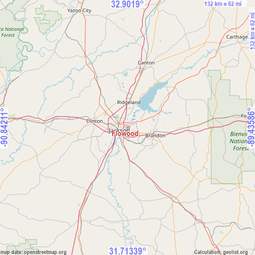
Flowood GPS coordinates[2]
32° 18' 34.524" North, 90° 8' 20.328" West
| Map corner | latitude | longitude |
|---|---|---|
| Upper-left | 32.9019°, | -90.84211° |
| Center: | 32.30959°, | -90.13898° |
| Lower-right: | 31.71339°, | -89.43586° |
| Map W x H: | 132.1×132.2 km | = 82.1×82.1mi |
| max Lat: | 71.29058° ⇑87.8% North |
| Flowood: | 32.30959° |
| min Lat: | ⇓12.2% South 19.06759° |
| min Long | Flowood | max Long |
| -171.73463° | -90.13898° | -66.98998° |
| W 40.6%⇐ | ⇒59.4% E |
Elevation
Elevation of Flowood is 88 m = 289 ft, and this is 206.8 m = 678 ft below average elevation for this country.
| Max E: |
3189 m = 10463 ft | 72.1% |
| Avg. | 294.8 m = 967 ft | |
| Flowood | 88 m = 289 ft | |
Min E: |
-60 m = -197 ft | 27.9% |
See also: United States elevation on elevation.city.
Geographical zone
Flowood is located in North temperate zone (between Tropic of Cancer and the Arctic Circle). Distance of this Northern Tropic circle is 986.6 km =613 mi to South.| Distance of | km | miles | from Flowood |
|---|---|---|---|
| North Pole | 6414.6 | 3985.8 | to North |
| Arctic Circle | 3808.7 | 2366.6 | to North |
| Tropic Cancer | 986.6 | 613 | to South |
| Equator | 3592.5 | 2232.3 | to South |


Nearby cities:
15 places around Flowood: (largest is in red/bold)
• Bolton
30.5 km =19 mi,  278°
278°
• Brandon
14.9 km =9.3 mi,  105°
105°
• Byram
17.6 km =10.9 mi,  214°
214°
• Cleary
16.5 km =10.3 mi,  193°
193°
• Clinton
17.5 km =10.9 mi, 281°
• Flora
30.5 km =19 mi,  328°
328°
• Florence
17.4 km =10.8 mi,  177°
177°
• Jackson
4.5 km =2.8 mi,  254°
254°
• Madison
17.1 km =10.6 mi,  7°
7°
• Pearl
3.9 km =2.4 mi,  170°
170°
• Pelahatchie
32 km =19.9 mi,  89°
89°
• Raymond
27.2 km =16.9 mi,  258°
258°
• Richland
8.1 km =5 mi, 193°
• Ridgeland
13.2 km =8.2 mi,  2°
2°
• Terry
27.9 km =17.3 mi, 211°
Sources, notices
• [Note1] Compared only with cities in United States existing in our database
• [Src1] Map data: © OpenStreetMap contributors (CC-BY-SA)
• [Src2] Other city data from geonames.org with taken over terms of usage.
• [Src3] Geographical zone / Annual Mean Temperature by Robert A. Rohde @ Wikipedia
