Jackson geodata
Jackson (Mississippi) is a seat of a first-order administrative division; located in United States in America/Chicago (GMT-5) time zone. With population of 170,674 people, there are 164 cities with bigger population in this country. Compared to other cities in United States, 87.8% of cities are located further ↑North; 59.6% of cities are located further →East and 70.1% of cities have higher elevation than Jackson. Note1


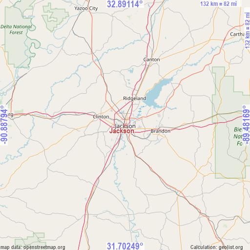
Jackson GPS coordinates[2]
32° 17' 55.536" North, 90° 11' 5.316" West
| Map corner | latitude | longitude |
|---|---|---|
| Upper-left | 32.89114°, | -90.88794° |
| Center: | 32.29876°, | -90.18481° |
| Lower-right: | 31.70249°, | -89.48169° |
| Map W x H: | 132.2×132.2 km | = 82.1×82.1mi |
| max Lat: | 71.29058° ⇑87.8% North |
| Jackson: | 32.29876° |
| min Lat: | ⇓12.2% South 19.06759° |
| min Long | Jackson | max Long |
| -171.73463° | -90.18481° | -66.98998° |
| W 40.4%⇐ | ⇒59.6% E |
Elevation
Elevation of Jackson is 100 m = 328 ft, and this is 194.8 m = 639 ft below average elevation for this country.
| Max E: |
3189 m = 10463 ft | 70.1% |
| Avg. | 294.8 m = 967 ft | |
| Jackson | 100 m = 328 ft | |
Min E: |
-60 m = -197 ft | 29.9% |
See also: Jackson elevation on elevation.city.
Geographical zone
Jackson is located in North temperate zone (between Tropic of Cancer and the Arctic Circle). Distance of this Northern Tropic circle is 985.4 km =612.3 mi to South.| Distance of | km | miles | from Jackson |
|---|---|---|---|
| North Pole | 6415.8 | 3986.6 | to North |
| Arctic Circle | 3809.9 | 2367.4 | to North |
| Tropic Cancer | 985.4 | 612.3 | to South |
| Equator | 3591.3 | 2231.5 | to South |


Nearby cities:
15 places around Jackson: (largest is in red/bold)
• Bolton
26.5 km =16.5 mi,  282°
282°
• Brandon
18.9 km =11.7 mi,  98°
98°
• Byram
14.5 km =9 mi,  203°
203°
• Cleary
14.8 km =9.2 mi,  178°
178°
• Clinton
13.7 km =8.5 mi,  290°
290°
• Flora
29.6 km =18.4 mi,  336°
336°
• Florence
16.9 km =10.5 mi,  162°
162°
• Flowood
4.5 km =2.8 mi,  74°
74°
• Kearney Park
34.5 km =21.4 mi, 339°
• Madison
19.3 km =12 mi,  19°
19°
• Pearl
5.6 km =3.5 mi,  118°
118°
• Raymond
22.8 km =14.2 mi,  258°
258°
• Richland
7.1 km =4.4 mi, 159°
• Ridgeland
15.2 km =9.4 mi, 18°
• Terry
24.8 km =15.4 mi, 204°
Sources, notices
• [Note1] Compared only with cities in United States existing in our database
• [Src1] Map data: © OpenStreetMap contributors (CC-BY-SA)
• [Src2] Other city data from geonames.org with taken over terms of usage.
• [Src3] Geographical zone / Annual Mean Temperature by Robert A. Rohde @ Wikipedia
