Pearl geodata
Pearl (Mississippi) is a populated place; located in United States in America/Chicago (GMT-5) time zone. With population of 26,462 people, there are 1896 cities with bigger population in this country. Compared to other cities in United States, 87.9% of cities are located further ↑North; 59.4% of cities are located further →East and 72% of cities have higher elevation than Pearl. Note1


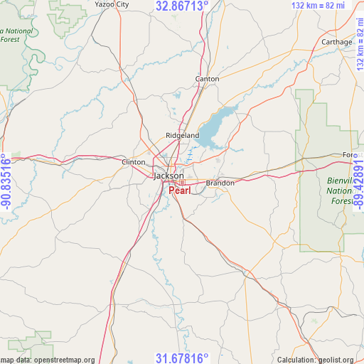
Pearl GPS coordinates[2]
32° 16' 28.524" North, 90° 7' 55.308" West
| Map corner | latitude | longitude |
|---|---|---|
| Upper-left | 32.86713°, | -90.83516° |
| Center: | 32.27459°, | -90.13203° |
| Lower-right: | 31.67816°, | -89.42891° |
| Map W x H: | 132.2×132.2 km | = 82.1×82.1mi |
| max Lat: | 71.29058° ⇑87.9% North |
| Pearl: | 32.27459° |
| min Lat: | ⇓12.1% South 19.06759° |
| min Long | Pearl | max Long |
| -171.73463° | -90.13203° | -66.98998° |
| W 40.6%⇐ | ⇒59.4% E |
Elevation
Elevation of Pearl is 89 m = 292 ft, and this is 205.8 m = 675 ft below average elevation for this country.
| Max E: |
3189 m = 10463 ft | 72% |
| Avg. | 294.8 m = 967 ft | |
| Pearl | 89 m = 292 ft | |
Min E: |
-60 m = -197 ft | 28% |
See also: United States elevation on elevation.city.
Geographical zone
Pearl is located in North temperate zone (between Tropic of Cancer and the Arctic Circle). Distance of this Northern Tropic circle is 982.7 km =610.6 mi to South.| Distance of | km | miles | from Pearl |
|---|---|---|---|
| North Pole | 6418.5 | 3988.3 | to North |
| Arctic Circle | 3812.6 | 2369 | to North |
| Tropic Cancer | 982.7 | 610.6 | to South |
| Equator | 3588.6 | 2229.9 | to South |


Nearby cities:
15 places around Pearl: (largest is in red/bold)
• Bolton
31.9 km =19.8 mi,  285°
285°
• Brandon
13.7 km =8.5 mi,  90°
90°
• Byram
15 km =9.3 mi,  225°
225°
• Cleary
13 km =8.1 mi,  200°
200°
• Clinton
19.3 km =12 mi, 292°
• Flora
34.2 km =21.3 mi,  330°
330°
• Florence
13.5 km =8.4 mi,  179°
179°
• Flowood
3.9 km =2.4 mi,  350°
350°
• Jackson
5.6 km =3.5 mi,  298°
298°
• Madison
20.9 km =13 mi,  4°
4°
• Pelahatchie
31.6 km =19.6 mi,  82°
82°
• Raymond
27.4 km =17 mi,  266°
266°
• Richland
4.7 km =2.9 mi,  212°
212°
• Ridgeland
17.1 km =10.6 mi,  359°
359°
• Terry
25 km =15.5 mi,  217°
217°
Sources, notices
• [Note1] Compared only with cities in United States existing in our database
• [Src1] Map data: © OpenStreetMap contributors (CC-BY-SA)
• [Src2] Other city data from geonames.org with taken over terms of usage.
• [Src3] Geographical zone / Annual Mean Temperature by Robert A. Rohde @ Wikipedia
