Columbia geodata
Columbia (Mississippi) is a seat of a second-order administrative division; located in United States in America/Chicago (GMT-5) time zone. With population of 6,229 people, there are 6253 cities with bigger population in this country. Compared to other cities in United States, 90.2% of cities are located further ↑North; 58.5% of cities are located further →East and 79.7% of cities have higher elevation than Columbia. Note1


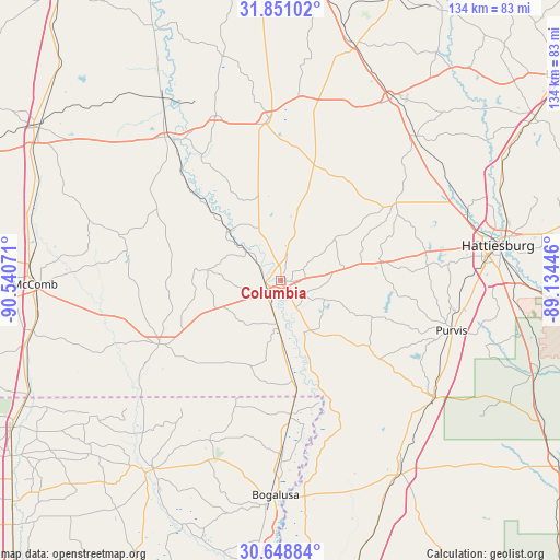
Columbia GPS coordinates[2]
31° 15' 6.624" North, 89° 50' 15.288" West
| Map corner | latitude | longitude |
|---|---|---|
| Upper-left | 31.85102°, | -90.54071° |
| Center: | 31.25184°, | -89.83758° |
| Lower-right: | 30.64884°, | -89.13446° |
| Map W x H: | 133.7×133.7 km | = 83.1×83.1mi |
| max Lat: | 71.29058° ⇑90.2% North |
| Columbia: | 31.25184° |
| min Lat: | ⇓9.8% South 19.06759° |
| min Long | Columbia | max Long |
| -171.73463° | -89.83758° | -66.98998° |
| W 41.5%⇐ | ⇒58.5% E |
Elevation
Elevation of Columbia is 48 m = 157 ft, and this is 246.8 m = 810 ft below average elevation for this country.
| Max E: |
3189 m = 10463 ft | 79.7% |
| Avg. | 294.8 m = 967 ft | |
| Columbia | 48 m = 157 ft | |
Min E: |
-60 m = -197 ft | 20.3% |
See also: United States elevation on elevation.city.
Geographical zone
Columbia is located in North temperate zone (between Tropic of Cancer and the Arctic Circle). Distance of this Northern Tropic circle is 869 km =540 mi to South.| Distance of | km | miles | from Columbia |
|---|---|---|---|
| North Pole | 6532.2 | 4058.9 | to North |
| Arctic Circle | 3926.3 | 2439.7 | to North |
| Tropic Cancer | 869 | 540 | to South |
| Equator | 3474.9 | 2159.2 | to South |


Nearby cities:
15 places around Columbia: (largest is in red/bold)
• Arnold Line
45.1 km =28 mi,  78°
78°
• Bogalusa
51.2 km =31.8 mi,  181°
181°
• Collins
51.3 km =31.9 mi,  31°
31°
• Foxworth
3.3 km =2.1 mi,  242°
242°
• Glendale
52 km =32.3 mi, 76°
• Hattiesburg
52.7 km =32.7 mi, 80°
• Holly Springs
15.1 km =9.4 mi,  298°
298°
• Lumberton
46.1 km =28.6 mi,  127°
127°
• Monticello
42.2 km =26.2 mi,  322°
322°
• Prentiss
38.6 km =24 mi,  355°
355°
• Purvis
42.4 km =26.3 mi,  106°
106°
• Rawls Springs
46.5 km =28.9 mi,  72°
72°
• Sumrall
33.5 km =20.8 mi,  56°
56°
• Tylertown
32.7 km =20.3 mi, 242°
• West Hattiesburg
44.6 km =27.7 mi, 80°
Sources, notices
• [Note1] Compared only with cities in United States existing in our database
• [Src1] Map data: © OpenStreetMap contributors (CC-BY-SA)
• [Src2] Other city data from geonames.org with taken over terms of usage.
• [Src3] Geographical zone / Annual Mean Temperature by Robert A. Rohde @ Wikipedia
