Sumrall geodata
Sumrall (Mississippi) is a populated place; located in United States in America/Chicago (GMT-5) time zone. With population of 1,711 people, there are 12871 cities with bigger population in this country. Compared to other cities in United States, 89.8% of cities are located further ↑North; 57.7% of cities are located further →East and 71.1% of cities have higher elevation than Sumrall. Note1


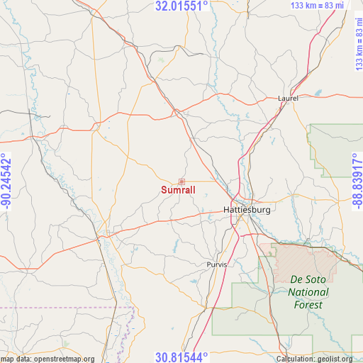
Sumrall GPS coordinates[2]
31° 25' 2.604" North, 89° 32' 32.244" West
| Map corner | latitude | longitude |
|---|---|---|
| Upper-left | 32.01551°, | -90.24542° |
| Center: | 31.41739°, | -89.54229° |
| Lower-right: | 30.81544°, | -88.83917° |
| Map W x H: | 133.4×133.4 km | = 82.9×82.9mi |
| max Lat: | 71.29058° ⇑89.8% North |
| Sumrall: | 31.41739° |
| min Lat: | ⇓10.2% South 19.06759° |
| min Long | Sumrall | max Long |
| -171.73463° | -89.54229° | -66.98998° |
| W 42.3%⇐ | ⇒57.7% E |
Elevation
Elevation of Sumrall is 94 m = 308 ft, and this is 200.8 m = 659 ft below average elevation for this country.
| Max E: |
3189 m = 10463 ft | 71.1% |
| Avg. | 294.8 m = 967 ft | |
| Sumrall | 94 m = 308 ft | |
Min E: |
-60 m = -197 ft | 28.9% |
See also: United States elevation on elevation.city.
Geographical zone
Sumrall is located in North temperate zone (between Tropic of Cancer and the Arctic Circle). Distance of this Northern Tropic circle is 887.4 km =551.4 mi to South.| Distance of | km | miles | from Sumrall |
|---|---|---|---|
| North Pole | 6513.8 | 4047.5 | to North |
| Arctic Circle | 3907.9 | 2428.3 | to North |
| Tropic Cancer | 887.4 | 551.4 | to South |
| Equator | 3493.3 | 2170.6 | to South |


Nearby cities:
15 places around Sumrall: (largest is in red/bold)
• Arnold Line
18.5 km =11.5 mi,  119°
119°
• Collins
25.4 km =15.8 mi,  357°
357°
• Columbia
33.5 km =20.8 mi,  236°
236°
• Ellisville
38.9 km =24.2 mi,  57°
57°
• Foxworth
36.8 km =22.9 mi, 237°
• Glendale
23.2 km =14.4 mi,  104°
104°
• Hattiesburg
25.9 km =16.1 mi,  112°
112°
• Holly Springs
42.9 km =26.7 mi,  254°
254°
• Mount Olive
39.7 km =24.7 mi,  344°
344°
• Petal
27.9 km =17.3 mi, 106°
• Prentiss
36.8 km =22.9 mi,  303°
303°
• Purvis
33 km =20.5 mi,  157°
157°
• Rawls Springs
16.7 km =10.4 mi, 104°
• Taylorsville
47.1 km =29.3 mi,  13°
13°
• West Hattiesburg
19.3 km =12 mi, 124°
Sources, notices
• [Note1] Compared only with cities in United States existing in our database
• [Src1] Map data: © OpenStreetMap contributors (CC-BY-SA)
• [Src2] Other city data from geonames.org with taken over terms of usage.
• [Src3] Geographical zone / Annual Mean Temperature by Robert A. Rohde @ Wikipedia
