De Kalb geodata
De Kalb (Mississippi) is a seat of a second-order administrative division; located in United States in America/Chicago (GMT-5) time zone. With population of 1,057 people, there are 15916 cities with bigger population in this country. Compared to other cities in United States, 86.1% of cities are located further ↑North; 55.3% of cities are located further →East and 62.6% of cities have higher elevation than De Kalb. Note1


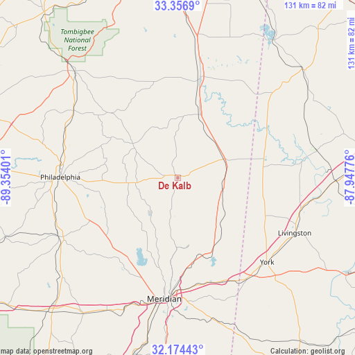
De Kalb GPS coordinates[2]
32° 46' 3.468" North, 88° 39' 3.168" West
| Map corner | latitude | longitude |
|---|---|---|
| Upper-left | 33.3569°, | -89.35401° |
| Center: | 32.76763°, | -88.65088° |
| Lower-right: | 32.17443°, | -87.94776° |
| Map W x H: | 131.5×131.5 km | = 81.7×81.7mi |
| max Lat: | 71.29058° ⇑86.1% North |
| De Kalb: | 32.76763° |
| min Lat: | ⇓13.9% South 19.06759° |
| min Long | De Kalb | max Long |
| -171.73463° | -88.65088° | -66.98998° |
| W 44.7%⇐ | ⇒55.3% E |
Elevation
Elevation of De Kalb is 141 m = 463 ft, and this is 153.8 m = 505 ft below average elevation for this country.
| Max E: |
3189 m = 10463 ft | 62.6% |
| Avg. | 294.8 m = 967 ft | |
| De Kalb | 141 m = 463 ft | |
Min E: |
-60 m = -197 ft | 37.4% |
See also: United States elevation on elevation.city.
Geographical zone
De Kalb is located in North temperate zone (between Tropic of Cancer and the Arctic Circle). Distance of this Northern Tropic circle is 1037.5 km =644.7 mi to South.| Distance of | km | miles | from De Kalb |
|---|---|---|---|
| North Pole | 6363.6 | 3954.2 | to North |
| Arctic Circle | 3757.8 | 2335 | to North |
| Tropic Cancer | 1037.5 | 644.7 | to South |
| Equator | 3643.4 | 2263.9 | to South |


Nearby cities:
15 places around De Kalb: (largest is in red/bold)
• Bogue Chitto
27.2 km =16.9 mi,  284°
284°
• Collinsville
35.1 km =21.8 mi,  211°
211°
• Deemer
43.8 km =27.2 mi,  266°
266°
• Livingston
47.9 km =29.8 mi,  115°
115°
• Macon
38.5 km =23.9 mi,  12°
12°
• Marion
38.9 km =24.2 mi,  179°
179°
• Meridian
45.1 km =28 mi,  186°
186°
• Meridian Station
24.3 km =15.1 mi,  172°
172°
• Nellieburg
41.8 km =26 mi,  196°
196°
• Philadelphia
43.6 km =27.1 mi, 270°
• Scooba
17.6 km =10.9 mi,  67°
67°
• Toomsuba
41.1 km =25.5 mi,  160°
160°
• Tucker
38.3 km =23.8 mi,  259°
259°
• Union
49.1 km =30.5 mi,  243°
243°
• York
45.6 km =28.3 mi,  133°
133°
Sources, notices
• [Note1] Compared only with cities in United States existing in our database
• [Src1] Map data: © OpenStreetMap contributors (CC-BY-SA)
• [Src2] Other city data from geonames.org with taken over terms of usage.
• [Src3] Geographical zone / Annual Mean Temperature by Robert A. Rohde @ Wikipedia
