De Lisle geodata
De Lisle (Mississippi) is a populated place; located in United States in America/Chicago (GMT-5) time zone. With population of 1,147 people, there are 15397 cities with bigger population in this country. Compared to other cities in United States, 92.3% of cities are located further ↑North; 56.9% of cities are located further →East and 95.7% of cities have higher elevation than De Lisle. Note1


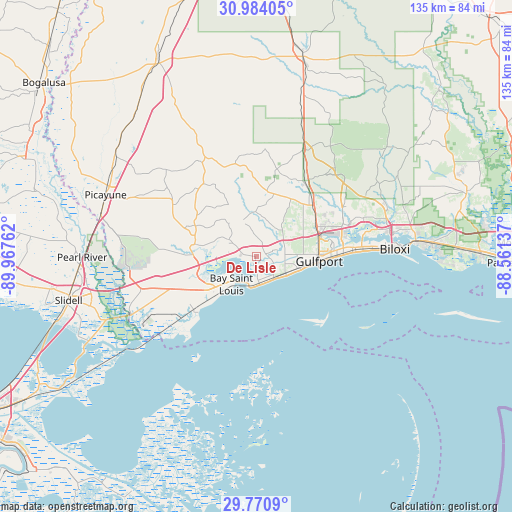
De Lisle GPS coordinates[2]
30° 22' 45.696" North, 89° 15' 52.164" West
| Map corner | latitude | longitude |
|---|---|---|
| Upper-left | 30.98405°, | -89.96762° |
| Center: | 30.37936°, | -89.26449° |
| Lower-right: | 29.7709°, | -88.56137° |
| Map W x H: | 134.9×134.9 km | = 83.8×83.8mi |
| max Lat: | 71.29058° ⇑92.3% North |
| De Lisle: | 30.37936° |
| min Lat: | ⇓7.7% South 19.06759° |
| min Long | De Lisle | max Long |
| -171.73463° | -89.26449° | -66.98998° |
| W 43.1%⇐ | ⇒56.9% E |
Elevation
Elevation of De Lisle is 8 m = 26 ft, and this is 286.8 m = 941 ft below average elevation for this country.
| Max E: |
3189 m = 10463 ft | 95.7% |
| Avg. | 294.8 m = 967 ft | |
| De Lisle | 8 m = 26 ft | |
Min E: |
-60 m = -197 ft | 4.3% |
See also: United States elevation on elevation.city.
Geographical zone
De Lisle is located in North temperate zone (between Tropic of Cancer and the Arctic Circle). Distance of this Northern Tropic circle is 771.9 km =479.6 mi to South.| Distance of | km | miles | from De Lisle |
|---|---|---|---|
| North Pole | 6629.2 | 4119.2 | to North |
| Arctic Circle | 4023.3 | 2500 | to North |
| Tropic Cancer | 771.9 | 479.6 | to South |
| Equator | 3377.9 | 2098.9 | to South |


Nearby cities:
15 places around De Lisle: (largest is in red/bold)
• Bay Saint Louis
10.1 km =6.3 mi,  218°
218°
• Biloxi
36.4 km =22.6 mi,  87°
87°
• D'Iberville
36.2 km =22.5 mi,  81°
81°
• Diamondhead
9.7 km =6 mi,  280°
280°
• Gulf Hills
40.9 km =25.4 mi, 82°
• Gulfport
16.5 km =10.3 mi, 94°
• Kiln
16.7 km =10.4 mi, 281°
• Long Beach
11.2 km =7 mi,  106°
106°
• Lyman
18.5 km =11.5 mi,  46°
46°
• Pass Christian
7.3 km =4.5 mi,  167°
167°
• Pearlington
36.4 km =22.6 mi,  246°
246°
• Saint Martin
38.6 km =24 mi, 80°
• Saucier
31.1 km =19.3 mi,  23°
23°
• Waveland
14.9 km =9.3 mi,  226°
226°
• West Gulfport
16.6 km =10.3 mi, 80°
Sources, notices
• [Note1] Compared only with cities in United States existing in our database
• [Src1] Map data: © OpenStreetMap contributors (CC-BY-SA)
• [Src2] Other city data from geonames.org with taken over terms of usage.
• [Src3] Geographical zone / Annual Mean Temperature by Robert A. Rohde @ Wikipedia
