Gulfport geodata
Gulfport (Mississippi) is a populated place; located in United States in America/Chicago (GMT-5) time zone. With population of 71,856 people, there are 575 cities with bigger population in this country. Compared to other cities in United States, 92.3% of cities are located further ↑North; 56.4% of cities are located further →East and 92.1% of cities have higher elevation than Gulfport. Note1


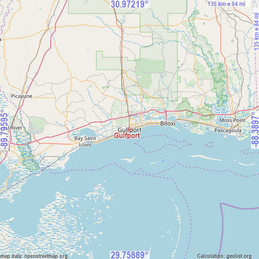
Gulfport GPS coordinates[2]
30° 22' 2.712" North, 89° 5' 34.152" West
| Map corner | latitude | longitude |
|---|---|---|
| Upper-left | 30.97219°, | -89.79595° |
| Center: | 30.36742°, | -89.09282° |
| Lower-right: | 29.75889°, | -88.3897° |
| Map W x H: | 134.9×134.9 km | = 83.8×83.8mi |
| max Lat: | 71.29058° ⇑92.3% North |
| Gulfport: | 30.36742° |
| min Lat: | ⇓7.7% South 19.06759° |
| min Long | Gulfport | max Long |
| -171.73463° | -89.09282° | -66.98998° |
| W 43.6%⇐ | ⇒56.4% E |
Elevation
Elevation of Gulfport is 12 m = 39 ft, and this is 282.8 m = 928 ft below average elevation for this country.
| Max E: |
3189 m = 10463 ft | 92.1% |
| Avg. | 294.8 m = 967 ft | |
| Gulfport | 12 m = 39 ft | |
Min E: |
-60 m = -197 ft | 7.9% |
See also: Gulfport elevation on elevation.city.
Geographical zone
Gulfport is located in North temperate zone (between Tropic of Cancer and the Arctic Circle). Distance of this Northern Tropic circle is 770.6 km =478.8 mi to South.| Distance of | km | miles | from Gulfport |
|---|---|---|---|
| North Pole | 6630.5 | 4120 | to North |
| Arctic Circle | 4024.6 | 2500.8 | to North |
| Tropic Cancer | 770.6 | 478.8 | to South |
| Equator | 3376.5 | 2098.1 | to South |


Nearby cities:
15 places around Gulfport: (largest is in red/bold)
• Bay Saint Louis
23.7 km =14.7 mi,  254°
254°
• Biloxi
20.2 km =12.6 mi,  80°
80°
• D'Iberville
20.4 km =12.7 mi,  71°
71°
• De Lisle
16.5 km =10.3 mi,  274°
274°
• Diamondhead
26.2 km =16.3 mi,  276°
276°
• Gulf Hills
25 km =15.5 mi, 73°
• Latimer
28.6 km =17.8 mi,  49°
49°
• Long Beach
6.1 km =3.8 mi, 251°
• Lyman
14.5 km =9 mi,  347°
347°
• Ocean Springs
25.9 km =16.1 mi, 79°
• Pass Christian
15.9 km =9.9 mi, 248°
• Saint Martin
22.9 km =14.2 mi, 69°
• Saucier
30.1 km =18.7 mi, 352°
• Waveland
28.6 km =17.8 mi, 251°
• West Gulfport
4.1 km =2.5 mi,  358°
358°
Sources, notices
• [Note1] Compared only with cities in United States existing in our database
• [Src1] Map data: © OpenStreetMap contributors (CC-BY-SA)
• [Src2] Other city data from geonames.org with taken over terms of usage.
• [Src3] Geographical zone / Annual Mean Temperature by Robert A. Rohde @ Wikipedia
