Enterprise geodata
Enterprise (Mississippi) is a populated place; located in United States in America/Chicago (GMT-5) time zone. With population of 503 people, there are 20865 cities with bigger population in this country. Compared to other cities in United States, 88.2% of cities are located further ↑North; 55.6% of cities are located further →East and 73.2% of cities have higher elevation than Enterprise. Note1


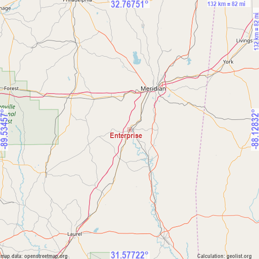
Enterprise GPS coordinates[2]
32° 10' 27.516" North, 88° 49' 53.184" West
| Map corner | latitude | longitude |
|---|---|---|
| Upper-left | 32.76751°, | -89.53457° |
| Center: | 32.17431°, | -88.83144° |
| Lower-right: | 31.57722°, | -88.12832° |
| Map W x H: | 132.3×132.3 km | = 82.2×82.2mi |
| max Lat: | 71.29058° ⇑88.2% North |
| Enterprise: | 32.17431° |
| min Lat: | ⇓11.8% South 19.06759° |
| min Long | Enterprise | max Long |
| -171.73463° | -88.83144° | -66.98998° |
| W 44.4%⇐ | ⇒55.6% E |
Elevation
Elevation of Enterprise is 82 m = 269 ft, and this is 212.8 m = 698 ft below average elevation for this country.
| Max E: |
3189 m = 10463 ft | 73.2% |
| Avg. | 294.8 m = 967 ft | |
| Enterprise | 82 m = 269 ft | |
Min E: |
-60 m = -197 ft | 26.8% |
See also: United States elevation on elevation.city.
Geographical zone
Enterprise is located in North temperate zone (between Tropic of Cancer and the Arctic Circle). Distance of this Northern Tropic circle is 971.5 km =603.7 mi to South.| Distance of | km | miles | from Enterprise |
|---|---|---|---|
| North Pole | 6429.6 | 3995.2 | to North |
| Arctic Circle | 3823.7 | 2375.9 | to North |
| Tropic Cancer | 971.5 | 603.7 | to South |
| Equator | 3577.4 | 2222.9 | to South |


Nearby cities:
15 places around Enterprise: (largest is in red/bold)
• Bay Springs
48.1 km =29.9 mi,  243°
243°
• Collinsville
36 km =22.4 mi,  357°
357°
• Decatur
39.3 km =24.4 mi,  318°
318°
• Heidelberg
35 km =21.7 mi,  204°
204°
• Hickory
24.2 km =15 mi,  311°
311°
• Marion
32.1 km =19.9 mi,  32°
32°
• Meridian
24.3 km =15.1 mi, 29°
• Meridian Station
46.4 km =28.8 mi, 25°
• Nellieburg
26.3 km =16.3 mi,  11°
11°
• Newton
35.2 km =21.9 mi,  297°
297°
• Quitman
17.8 km =11.1 mi,  146°
146°
• Sandersville
47.2 km =29.3 mi, 203°
• Sharon
49.6 km =30.8 mi,  210°
210°
• Stonewall
5.9 km =3.7 mi,  142°
142°
• Toomsuba
40.8 km =25.4 mi,  48°
48°
Sources, notices
• [Note1] Compared only with cities in United States existing in our database
• [Src1] Map data: © OpenStreetMap contributors (CC-BY-SA)
• [Src2] Other city data from geonames.org with taken over terms of usage.
• [Src3] Geographical zone / Annual Mean Temperature by Robert A. Rohde @ Wikipedia
