Stonewall geodata
Stonewall (Mississippi) is a populated place; located in United States in America/Chicago (GMT-5) time zone. With population of 1,031 people, there are 16075 cities with bigger population in this country. Compared to other cities in United States, 88.3% of cities are located further ↑North; 55.6% of cities are located further →East and 75.1% of cities have higher elevation than Stonewall. Note1


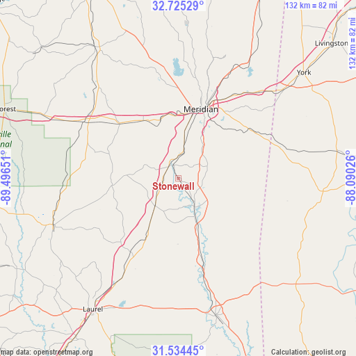
Stonewall GPS coordinates[2]
32° 7' 54.516" North, 88° 47' 36.168" West
| Map corner | latitude | longitude |
|---|---|---|
| Upper-left | 32.72529°, | -89.49651° |
| Center: | 32.13181°, | -88.79338° |
| Lower-right: | 31.53445°, | -88.09026° |
| Map W x H: | 132.4×132.4 km | = 82.3×82.3mi |
| max Lat: | 71.29058° ⇑88.3% North |
| Stonewall: | 32.13181° |
| min Lat: | ⇓11.7% South 19.06759° |
| min Long | Stonewall | max Long |
| -171.73463° | -88.79338° | -66.98998° |
| W 44.4%⇐ | ⇒55.6% E |
Elevation
Elevation of Stonewall is 71 m = 233 ft, and this is 223.8 m = 734 ft below average elevation for this country.
| Max E: |
3189 m = 10463 ft | 75.1% |
| Avg. | 294.8 m = 967 ft | |
| Stonewall | 71 m = 233 ft | |
Min E: |
-60 m = -197 ft | 24.9% |
See also: United States elevation on elevation.city.
Geographical zone
Stonewall is located in North temperate zone (between Tropic of Cancer and the Arctic Circle). Distance of this Northern Tropic circle is 966.8 km =600.7 mi to South.| Distance of | km | miles | from Stonewall |
|---|---|---|---|
| North Pole | 6434.3 | 3998.1 | to North |
| Arctic Circle | 3828.5 | 2378.9 | to North |
| Tropic Cancer | 966.8 | 600.7 | to South |
| Equator | 3572.7 | 2220 | to South |


Nearby cities:
15 places around Stonewall: (largest is in red/bold)
• Collinsville
41 km =25.5 mi,  353°
353°
• Decatur
45.2 km =28.1 mi,  319°
319°
• Enterprise
5.9 km =3.7 mi, 322°
• Heidelberg
32.6 km =20.3 mi,  213°
213°
• Hickory
30.1 km =18.7 mi,  313°
313°
• Lisman
48.3 km =30 mi,  85°
85°
• Marion
34.6 km =21.5 mi,  23°
23°
• Meridian
27.2 km =16.9 mi, 18°
• Meridian Station
49.4 km =30.7 mi, 19°
• Nellieburg
30.6 km =19 mi,  2°
2°
• Newton
40.7 km =25.3 mi,  301°
301°
• Quitman
11.9 km =7.4 mi,  148°
148°
• Sandersville
44.6 km =27.7 mi, 210°
• Sharon
47.7 km =29.6 mi,  217°
217°
• Toomsuba
41.7 km =25.9 mi,  40°
40°
Sources, notices
• [Note1] Compared only with cities in United States existing in our database
• [Src1] Map data: © OpenStreetMap contributors (CC-BY-SA)
• [Src2] Other city data from geonames.org with taken over terms of usage.
• [Src3] Geographical zone / Annual Mean Temperature by Robert A. Rohde @ Wikipedia
