Newton geodata
Newton (Mississippi) is a populated place; located in United States in America/Chicago (GMT-5) time zone. With population of 3,356 people, there are 9056 cities with bigger population in this country. Compared to other cities in United States, 87.7% of cities are located further ↑North; 56.6% of cities are located further →East and 64.7% of cities have higher elevation than Newton. Note1


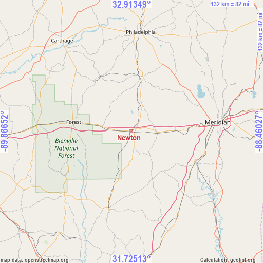
Newton GPS coordinates[2]
32° 19' 16.536" North, 89° 9' 48.204" West
| Map corner | latitude | longitude |
|---|---|---|
| Upper-left | 32.91349°, | -89.86652° |
| Center: | 32.32126°, | -89.16339° |
| Lower-right: | 31.72513°, | -88.46027° |
| Map W x H: | 132.1×132.1 km | = 82.1×82.1mi |
| max Lat: | 71.29058° ⇑87.7% North |
| Newton: | 32.32126° |
| min Lat: | ⇓12.3% South 19.06759° |
| min Long | Newton | max Long |
| -171.73463° | -89.16339° | -66.98998° |
| W 43.4%⇐ | ⇒56.6% E |
Elevation
Elevation of Newton is 130 m = 427 ft, and this is 164.8 m = 541 ft below average elevation for this country.
| Max E: |
3189 m = 10463 ft | 64.7% |
| Avg. | 294.8 m = 967 ft | |
| Newton | 130 m = 427 ft | |
Min E: |
-60 m = -197 ft | 35.3% |
See also: United States elevation on elevation.city.
Geographical zone
Newton is located in North temperate zone (between Tropic of Cancer and the Arctic Circle). Distance of this Northern Tropic circle is 987.9 km =613.9 mi to South.| Distance of | km | miles | from Newton |
|---|---|---|---|
| North Pole | 6413.3 | 3985 | to North |
| Arctic Circle | 3807.4 | 2365.8 | to North |
| Tropic Cancer | 987.9 | 613.9 | to South |
| Equator | 3593.8 | 2233.1 | to South |


Nearby cities:
15 places around Newton: (largest is in red/bold)
• Bay Springs
39.8 km =24.7 mi,  197°
197°
• Coldwater
44 km =27.3 mi,  353°
353°
• Collinsville
35.7 km =22.2 mi,  56°
56°
• Conehatta
18.4 km =11.4 mi,  321°
321°
• Decatur
14.1 km =8.8 mi,  21°
21°
• Enterprise
35.2 km =21.9 mi,  117°
117°
• Forest
29.6 km =18.4 mi,  279°
279°
• Hickory
13 km =8.1 mi,  91°
91°
• Hillsboro
36.1 km =22.4 mi,  295°
295°
• Meridian
43.5 km =27 mi,  83°
83°
• Nellieburg
37.5 km =23.3 mi, 75°
• Stonewall
40.7 km =25.3 mi, 121°
• Tucker
44 km =27.3 mi,  13°
13°
• Union
28.1 km =17.5 mi, 8°
• Walnut Grove
40.8 km =25.4 mi, 317°
Sources, notices
• [Note1] Compared only with cities in United States existing in our database
• [Src1] Map data: © OpenStreetMap contributors (CC-BY-SA)
• [Src2] Other city data from geonames.org with taken over terms of usage.
• [Src3] Geographical zone / Annual Mean Temperature by Robert A. Rohde @ Wikipedia
