Holcomb geodata
Holcomb (Mississippi) is a populated place; located in United States in America/Chicago (GMT-5) time zone. With population of 600 people, there are 19702 cities with bigger population in this country. Compared to other cities in United States, 81.7% of cities are located further ↑North; 58.9% of cities are located further →East and 77.1% of cities have higher elevation than Holcomb. Note1


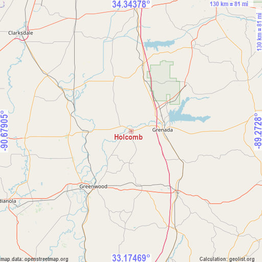
Holcomb GPS coordinates[2]
33° 45' 40.428" North, 89° 58' 33.312" West
| Map corner | latitude | longitude |
|---|---|---|
| Upper-left | 34.34378°, | -90.67905° |
| Center: | 33.76123°, | -89.97592° |
| Lower-right: | 33.17469°, | -89.2728° |
| Map W x H: | 130×130 km | = 80.8×80.8mi |
| max Lat: | 71.29058° ⇑81.7% North |
| Holcomb: | 33.76123° |
| min Lat: | ⇓18.3% South 19.06759° |
| min Long | Holcomb | max Long |
| -171.73463° | -89.97592° | -66.98998° |
| W 41.1%⇐ | ⇒58.9% E |
Elevation
Elevation of Holcomb is 60 m = 197 ft, and this is 234.8 m = 770 ft below average elevation for this country.
| Max E: |
3189 m = 10463 ft | 77.1% |
| Avg. | 294.8 m = 967 ft | |
| Holcomb | 60 m = 197 ft | |
Min E: |
-60 m = -197 ft | 22.9% |
See also: United States elevation on elevation.city.
Geographical zone
Holcomb is located in North temperate zone (between Tropic of Cancer and the Arctic Circle). Distance of this Northern Tropic circle is 1148 km =713.3 mi to South.| Distance of | km | miles | from Holcomb |
|---|---|---|---|
| North Pole | 6253.2 | 3885.6 | to North |
| Arctic Circle | 3647.3 | 2266.3 | to North |
| Tropic Cancer | 1148 | 713.3 | to South |
| Equator | 3753.9 | 2332.6 | to South |


Nearby cities:
15 places around Holcomb: (largest is in red/bold)
• Carrollton
28.6 km =17.8 mi,  169°
169°
• Charleston
28.3 km =17.6 mi,  344°
344°
• Coffeeville
36.6 km =22.7 mi,  49°
49°
• Crowder
48.2 km =30 mi, 341°
• Duck Hill
28.3 km =17.6 mi,  120°
120°
• Elliott
22.7 km =14.1 mi,  112°
112°
• Greenwood
33.1 km =20.6 mi,  214°
214°
• Grenada
15.5 km =9.6 mi,  86°
86°
• Itta Bena
43.5 km =27 mi,  227°
227°
• Mikoma
35.4 km =22 mi,  306°
306°
• Oakland
33.2 km =20.6 mi,  9°
9°
• Sidon
44.6 km =27.7 mi, 208°
• Tutwiler
50.6 km =31.4 mi,  303°
303°
• Webb
39.8 km =24.7 mi, 301°
• Winona
38.6 km =24 mi,  143°
143°
Sources, notices
• [Note1] Compared only with cities in United States existing in our database
• [Src1] Map data: © OpenStreetMap contributors (CC-BY-SA)
• [Src2] Other city data from geonames.org with taken over terms of usage.
• [Src3] Geographical zone / Annual Mean Temperature by Robert A. Rohde @ Wikipedia
