Troy geodata
Troy (North Carolina) is a seat of a second-order administrative division; located in United States in America/New_York (GMT-4) time zone. With population of 3,427 people, there are 8947 cities with bigger population in this country. Compared to other cities in United States, 73.4% of cities are located further ↑North; 73.7% of cities are located further ←West and 51% of cities have lower elevation than Troy. Note1
Administrative division(s):
- Level 1: North Carolina
- Level 2: Montgomery County
- Level 3: Township of Troy


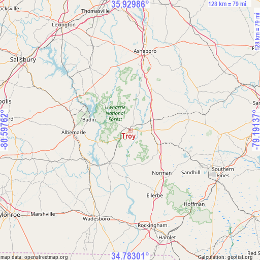
Troy GPS coordinates[2]
35° 21' 30.492" North, 79° 53' 40.164" West
| Map corner | latitude | longitude |
|---|---|---|
| Upper-left | 35.92986°, | -80.59762° |
| Center: | 35.35847°, | -79.89449° |
| Lower-right: | 34.78301°, | -79.19137° |
| Map W x H: | 127.5×127.5 km | = 79.2×79.2mi |
| max Lat: | 71.29058° ⇑73.4% North |
| Troy: | 35.35847° |
| min Lat: | ⇓26.6% South 19.06759° |
| min Long | Troy | max Long |
| -171.73463° | -79.89449° | -66.98998° |
| W 73.7%⇐ | ⇒26.3% E |
Elevation
Elevation of Troy is 202 m = 663 ft, and this is 92.8 m = 304 ft below average elevation for this country.
| Max E: |
3189 m = 10463 ft | 49% |
| Avg. | 294.8 m = 967 ft | |
| Troy | 202 m = 663 ft | |
Min E: |
-60 m = -197 ft | 51% |
See also: United States elevation on elevation.city.
Geographical zone
Troy is located in North temperate zone (between Tropic of Cancer and the Arctic Circle). Distance of this Northern Tropic circle is 1325.6 km =823.7 mi to South.| Distance of | km | miles | from Troy |
|---|---|---|---|
| North Pole | 6075.6 | 3775.2 | to North |
| Arctic Circle | 3469.7 | 2156 | to North |
| Tropic Cancer | 1325.6 | 823.7 | to South |
| Equator | 3931.5 | 2442.9 | to South |


Nearby cities:
15 places around Troy: (largest is in red/bold)
• Albemarle
27.7 km =17.2 mi,  268°
268°
• Ansonville
34.3 km =21.3 mi,  214°
214°
• Badin
20.8 km =12.9 mi,  284°
284°
• Biscoe
10.4 km =6.5 mi,  89°
89°
• Candor
15.3 km =9.5 mi,  117°
117°
• Denton
36.6 km =22.7 mi,  326°
326°
• Ellerbe
34.1 km =21.2 mi,  159°
159°
• Foxfire
35.7 km =22.2 mi, 124°
• Mount Gilead
18.7 km =11.6 mi, 211°
• New London
30.9 km =19.2 mi,  287°
287°
• Norwood
25.6 km =15.9 mi,  232°
232°
• Richfield
35.2 km =21.9 mi, 290°
• Robbins
29.1 km =18.1 mi,  73°
73°
• Seven Lakes
31.2 km =19.4 mi,  106°
106°
• Star
11.1 km =6.9 mi,  64°
64°
Sources, notices
• [Note1] Compared only with cities in United States existing in our database
• [Src1] Map data: © OpenStreetMap contributors (CC-BY-SA)
• [Src2] Other city data from geonames.org with taken over terms of usage.
• [Src3] Geographical zone / Annual Mean Temperature by Robert A. Rohde @ Wikipedia
